Category:Archaeological sites in Kentucky
Jump to navigation
Jump to search
States of the United States: Alabama · Alaska · Arizona · Arkansas · California · Colorado · Connecticut · Delaware · Florida · Georgia · Hawaii · Idaho · Illinois · Indiana · Iowa · Kansas · Kentucky · Louisiana · Maine · Maryland · Massachusetts · Michigan · Minnesota · Mississippi · Missouri · Montana · Nebraska · Nevada · New Hampshire · New Jersey · New Mexico · New York · North Carolina · North Dakota · Ohio · Oklahoma · Oregon · Pennsylvania · Rhode Island · South Carolina · South Dakota · Tennessee · Texas · Utah · Vermont · Virginia · Washington · West Virginia · Wisconsin · Wyoming – Washington, D.C.
Guam · Puerto Rico · United States Virgin Islands
Guam · Puerto Rico · United States Virgin Islands
Wikimedia category | |||||
| Upload media | |||||
| Instance of | |||||
|---|---|---|---|---|---|
| Category combines topics | |||||
| Kentucky | |||||
state of the United States of America     | |||||
| Pronunciation audio | |||||
| Instance of | |||||
| Part of | |||||
| Named after | |||||
| Location |
| ||||
| Located in or next to body of water | |||||
| Capital | |||||
| Legislative body | |||||
| Executive body | |||||
| Highest judicial authority |
| ||||
| Official language | |||||
| Anthem |
| ||||
| Head of government |
| ||||
| Inception |
| ||||
| Highest point | |||||
| Population |
| ||||
| Area |
| ||||
| Elevation above sea level |
| ||||
| Replaces |
| ||||
| Different from | |||||
| Maximum temperature record |
| ||||
| Minimum temperature record |
| ||||
| official website | |||||
 | |||||
Subcategories
This category has the following 6 subcategories, out of 6 total.
Media in category "Archaeological sites in Kentucky"
The following 21 files are in this category, out of 21 total.
-
 78-counties.jpg 1,293 × 2,126; 1.2 MB
-
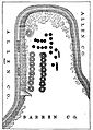
 82-Plan 1.jpg 2,255 × 1,391; 718 KB
-
 84-Plan 2.jpg 1,510 × 2,116; 997 KB
-
 Archaeological Site 15DA39 from east.jpg 2,816 × 1,584; 1 MB
-
 Archeological Site 15McL18.jpg 2,816 × 1,584; 1.34 MB
-
 Barren Fork Cemetery from parking area.jpg 6,016 × 4,000; 6.28 MB
-
 Chambers Site from east-northeast.jpg 2,816 × 1,584; 1.1 MB
-
 Fish Trap Rock Petroglyphs site.jpg 6,016 × 4,000; 6.5 MB
-
 Fort Star from high school parking lot.jpg 2,816 × 1,584; 1.67 MB
-
 GaitskillMoundKentucky.jpg 3,072 × 2,048; 2.59 MB
-
 I-24 southbound nearing Paducah, over archaeological site.jpg 2,816 × 1,584; 904 KB
-
 Jacob Hiestand House.jpg 2,816 × 1,584; 2.04 MB
-
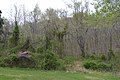
 Looking toward the Marshall Site.jpg 2,816 × 1,584; 1.44 MB
-
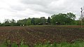
 Looking toward the Turk Site.jpg 2,816 × 1,584; 1.53 MB
-
 Lost River Cave entrance.jpg 2,816 × 1,584; 1.64 MB
-
 North toward the Stone Serpent.jpg 6,016 × 4,000; 6.35 MB
-
 Portland Wharf Park from level of 1937 flood.jpg 2,816 × 1,584; 1.18 MB
-
 Red Bird River Shelter Petroglyphs 1.jpg 3,456 × 2,304; 4.33 MB
-
 RoundHillKentuckyMound.jpg 3,072 × 2,048; 2.83 MB
-
 Sassafras Ridge Site mound.jpg 2,816 × 1,584; 1.42 MB
-
 Snag Creek Site.jpg 2,816 × 1,584; 972 KB


