Category:Antoniuskerk, Vorden
Jump to navigation
Jump to search
| Object location | | View all coordinates using: OpenStreetMap |
|---|
church building in Bronckhorst, Netherlands  | |||||
| Upload media | |||||
| Instance of | |||||
|---|---|---|---|---|---|
| Location | Vorden, Gelderland, Netherlands | ||||
| Street address |
| ||||
| Located on street |
| ||||
| Heritage designation |
| ||||
| Inception |
| ||||
 | |||||
|
This is a category about rijksmonument number 38120
|
| Address |
|
Media in category "Antoniuskerk, Vorden"
The following 35 files are in this category, out of 35 total.
-
 Antonius kerk Vorden.jpg 3,000 × 4,000; 3.16 MB
-
 Antoniuskerk Vorden zijaanzicht.jpg 3,000 × 4,000; 2.86 MB
-
 AntoniusVorden2020.jpg 3,648 × 5,472; 5.48 MB
-
 De kerk van Vorden zonder spits, Bestanddeelnr 919-1447.jpg 2,628 × 2,619; 1.47 MB
-
 Hervormde kerk Vorden.jpg 389 × 464; 20 KB
-
 Hervormde Pastorie-ingang - Vorden - 20246814 - RCE.jpg 903 × 1,200; 267 KB
-
 Interieur naar het oosten - Vorden - 20246804 - RCE.jpg 1,200 × 950; 158 KB
-
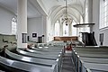
 Interieur naar het westen - Vorden - 20246803 - RCE.jpg 951 × 1,200; 183 KB
-
 Interieur, aanzicht orgel, orgelnummer 1581 - Vorden - 20349093 - RCE.jpg 790 × 1,200; 114 KB
-
 Interieur, bankenplan gezien vanaf de preekstoel - Vorden - 20531729 - RCE.jpg 1,200 × 800; 112 KB
-
 Interieur, bankenplan gezien vanaf de preekstoel - Vorden - 20531730 - RCE.jpg 1,200 × 800; 140 KB
-

-
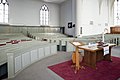
 Interieur, overzicht bankenplan - Vorden - 20531723 - RCE.jpg 1,200 × 800; 133 KB
-
 Interieur, overzicht bankenplan - Vorden - 20531724 - RCE.jpg 1,200 × 800; 114 KB
-

-

-

-
 Interieur, overzicht naar het westen - Vorden - 20531725 - RCE.jpg 1,200 × 800; 116 KB
-
 Interieur, overzicht orgel - Vorden - 20531727 - RCE.jpg 1,200 × 800; 123 KB
-
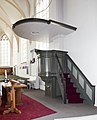
 Interieur, overzicht preekstoel - Vorden - 20531732 - RCE.jpg 1,200 × 800; 129 KB
-

-
 Interieur, preekstoel - Vorden - 20531731 - RCE.jpg 966 × 1,200; 152 KB
-

-
 Kerk - Vorden - 20246809 - RCE.jpg 899 × 1,200; 241 KB
-
 Kerk - Vorden - 20246810 - RCE.jpg 898 × 1,200; 229 KB
-
 Kerk - Vorden - 20246811 - RCE.jpg 898 × 1,200; 251 KB
-
 Kerk - Vorden - 20246812 - RCE.jpg 1,200 × 934; 334 KB
-
 Kerk vanuit het zuid-oosten - Vorden - 20246802 - RCE.jpg 1,200 × 881; 303 KB
-
 Kerk, inwendig naar het oosten - Vorden - 20246813 - RCE.jpg 889 × 1,200; 151 KB
-
 Overzicht noordoost gevel - Vorden - 20348256 - RCE.jpg 854 × 1,200; 140 KB
-
 Reliëf met opschrift - Vorden - 20246805 - RCE.jpg 1,200 × 961; 253 KB
-
 Reliëf wapenschilden met helmtekens - Vorden - 20246806 - RCE.jpg 1,200 × 950; 206 KB
-
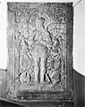
 Reliëfsteen- Aanbidding - Vorden - 20246807 - RCE.jpg 1,200 × 962; 219 KB
-
 Vorden,de Antoniuskerk RM38120, IMG 4820 2020-04-19 13.24.jpg 2,754 × 4,299; 8.11 MB
-
 Zerk van Berend van Haakfort - Vorden - 20246808 - RCE.jpg 949 × 1,200; 307 KB


