Category:Anping Bridge
Jump to navigation
Jump to search
中文(繁體):位於安海鎮端的安平橋
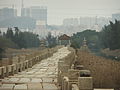
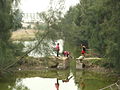
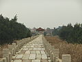
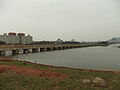
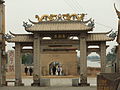
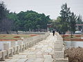
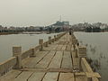
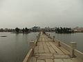
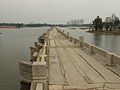
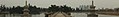
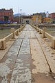
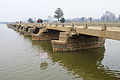
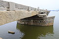
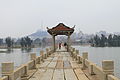
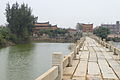
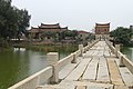
English: The ancient (Song Dynasty) Five-Li-long (i.e. about 2.5 km long) Anping Bridge spans what used to be the estuary of the Shijing River. The estuary has now mostly silted up, so most of the bridge is over various small lakes and wetlands; most of the area north and south of it is a park of sorts. The bridge connects Anhai Town (Jinjiang City) and Shuitou Town (Nan'an City), both in Quanzhou Prefecture, Fujian. The access to the eastern end of the bridge is via a path that runs by Shuixin Zen Temple. East of the present-day main channel of the Shijing River one finds Shuixin Pavilion; somewhere between the main channel and the western end of the bridge a small shrine called Xinxing Gong (新兴宫, "New Prosperity Palace") is located.
bridge in Quanzhou, China  | |||||
| Upload media | |||||
| Instance of | |||||
|---|---|---|---|---|---|
| Part of | |||||
| Made from material | |||||
| Location | Anhai Town, Jinjiang, Quanzhou, Fujian, PRC | ||||
| Crosses | |||||
| Heritage designation |
| ||||
| Length |
| ||||
| Area |
| ||||
 | |||||
Subcategories
This category has the following 2 subcategories, out of 2 total.
S
- Shuixin Pavilion (31 F)
X
- Xinxing Gong (Anping Bridge) (9 F)
Media in category "Anping Bridge"
The following 152 files are in this category, out of 152 total.
-
 Anping Bridge - dropped stone - DSCF9014.JPG 2,136 × 2,848; 2.5 MB
-
 Anping Bridge - east end - DSCF9015.JPG 2,848 × 2,136; 2.43 MB
-
 Anping Bridge - east end - DSCF9016.JPG 2,848 × 2,136; 2.38 MB
-
 Anping Bridge - east end - looking east - DSCF9047.JPG 2,848 × 2,136; 2.52 MB
-
 Anping Bridge - east end - looking east - DSCF9048.JPG 2,848 × 2,136; 2.39 MB
-
 Anping Bridge - east end - looking east - DSCF9049.JPG 2,848 × 2,136; 2.56 MB
-
 Anping Bridge - east end - looking east - DSCF9054.JPG 2,848 × 2,136; 2.47 MB
-
 Anping Bridge - east end - looking south - DSCF9057.JPG 2,048 × 1,536; 1.25 MB
-
 Anping Bridge - east end - looking SW - DSCF9058.JPG 2,048 × 1,536; 1.26 MB
-
 Anping Bridge - east end - looking SW - DSCF9059.JPG 2,048 × 1,536; 1.33 MB
-
 Anping Bridge - east end - looking west - DSCF9043.JPG 2,848 × 2,136; 2.38 MB
-
 Anping Bridge - east end - looking west - DSCF9044.JPG 2,848 × 2,136; 2.33 MB
-
 Anping Bridge - east end - looking west - DSCF9045.JPG 2,848 × 2,136; 2.38 MB
-
 Anping Bridge - east end - looking west - DSCF9046.JPG 2,848 × 2,136; 2.32 MB
-
 Anping Bridge - east end - looking west - DSCF9050.JPG 2,848 × 2,136; 2.46 MB
-
 Anping Bridge - east end - looking west - DSCF9051.JPG 2,848 × 2,136; 2.31 MB
-
 Anping Bridge - east end - looking west - DSCF9052.JPG 2,848 × 2,136; 2.5 MB
-
 Anping Bridge - east end - looking west - DSCF9053.JPG 2,848 × 2,136; 2.48 MB
-
 Anping Bridge - east end - looking west - DSCF9055.JPG 2,848 × 2,136; 2.41 MB
-
 Anping Bridge - east end - looking west - DSCF9056.JPG 2,848 × 2,136; 2.41 MB
-
 Anping Bridge - east end - looking west - DSCF9060.JPG 2,048 × 1,536; 1.26 MB
-
 Anping Bridge - eastern gate - DSCF9017.JPG 2,048 × 1,536; 1.45 MB
-
 Anping Bridge - eastern gate - DSCF9042.JPG 2,048 × 1,536; 1.46 MB
-
 Anping Bridge - eastern part - looking west - DSCF9012.JPG 2,848 × 2,136; 2.59 MB
-
 Anping Bridge - eastern part - looking west - DSCF9013.JPG 2,848 × 2,136; 2.44 MB
-
 Anping Bridge - kids playing nearby - DSCF9002.JPG 2,848 × 2,136; 2.59 MB
-
 Anping Bridge - looking east toward Shuixin Pavilion - DSCF9076.JPG 2,848 × 2,136; 2.46 MB
-
 Anping Bridge - looking east toward Shuixin Pavilion - DSCF9078.JPG 1,920 × 1,080; 1.01 MB
-
 Anping Bridge - looking east toward Shuixin Pavilion - DSCF9079.JPG 2,848 × 2,136; 2.57 MB
-
 Anping Bridge - looking toward the east end - DSCF8999.JPG 2,848 × 2,136; 2.45 MB
-
 Anping Bridge - looking toward the east end - DSCF9001.JPG 2,848 × 2,136; 2.44 MB
-
 Anping Bridge - looking toward the east end - DSCF9003.JPG 2,848 × 2,136; 2.41 MB
-
 Anping Bridge - looking toward the east end - DSCF9004.JPG 2,848 × 2,136; 2.46 MB
-
 Anping Bridge - looking toward the east end - DSCF9005.JPG 2,848 × 2,136; 2.42 MB
-
 Anping Bridge - looking toward the east end - DSCF9006.JPG 1,920 × 1,080; 1 MB
-
 Anping Bridge - looking toward the east end - DSCF9007.JPG 2,848 × 2,136; 2.41 MB
-
 Anping Bridge - looking toward the east end - DSCF9008.JPG 2,848 × 2,136; 2.44 MB
-
 Anping Bridge - looking toward the east end - DSCF9009.JPG 2,848 × 2,136; 2.45 MB
-
 Anping Bridge - looking toward the east end - DSCF9010.JPG 2,848 × 2,136; 2.41 MB
-
 Anping Bridge - looking toward the east end - DSCF9011.JPG 2,848 × 2,136; 2.43 MB
-
 Anping Bridge - looking west from Shuixin Pavilion - DSCF9070.JPG 2,848 × 2,136; 2.4 MB
-
 Anping Bridge - looking west from Shuixin Pavilion - DSCF9071.JPG 2,848 × 2,136; 2.53 MB
-
 Anping Bridge - looking west from Shuixin Pavilion - DSCF9072.JPG 2,848 × 2,136; 2.46 MB
-
 Anping Bridge - looking west from Shuixin Pavilion - DSCF9074.JPG 2,048 × 1,536; 1.3 MB
-
 Anping Bridge - looking west from Shuixin Pavilion - DSCF9075.JPG 2,848 × 2,136; 2.41 MB
-
 Anping Bridge - looking west toward Shuitou Town - DSCF9080.JPG 2,848 × 2,136; 2.26 MB
-
 Anping Bridge - looking west toward Shuitou Town - DSCF9081.JPG 2,848 × 2,136; 2.28 MB
-
 Anping Bridge - looking west toward Shuitou Town - DSCF9082.JPG 2,848 × 2,136; 2.29 MB
-
 Anping Bridge - looking west toward Shuitou Town - DSCF9083.JPG 2,848 × 2,136; 2.28 MB
-
 Anping Bridge - looking west toward Shuitou Town - DSCF9084.JPG 2,848 × 2,136; 2.31 MB
-
 Anping Bridge - looking west toward Shuitou Town - DSCF9085.JPG 2,848 × 2,136; 2.32 MB
-
 Anping Bridge - looking west toward Shuitou Town - DSCF9086.JPG 2,848 × 2,136; 2.39 MB
-
 Anping Bridge - looking west toward Shuitou Town - DSCF9087.JPG 2,848 × 2,136; 2.25 MB
-
 Anping Bridge - looking west toward Shuitou Town - DSCF9088.JPG 2,048 × 1,536; 1.37 MB
-
 Anping Bridge - pillars - DSCF9111.JPG 2,048 × 1,536; 1.41 MB
-
 Anping Bridge - pillars - DSCF9112.JPG 2,048 × 1,536; 1.42 MB
-
 Anping Bridge - pillars - DSCF9113.JPG 2,848 × 2,136; 2.43 MB
-
 Anping Bridge - pillars - DSCF9118.JPG 2,848 × 2,136; 2.38 MB
-
 Anping Bridge - pillars - DSCF9119.JPG 2,848 × 2,136; 2.53 MB
-
 Anping Bridge - pillars - DSCF9120.JPG 2,848 × 2,136; 2.46 MB
-
 Anping Bridge - pillars - DSCF9121.JPG 2,848 × 2,136; 2.55 MB
-
 Anping Bridge - pillars - DSCF9122.JPG 2,848 × 2,136; 2.6 MB
-
 Anping Bridge - seen from Shuitou - DSCF8934.JPG 2,048 × 1,536; 1.38 MB
-
 Anping Bridge - seen from Shuitou - DSCF8935.JPG 2,848 × 2,136; 2.45 MB
-
 Anping Bridge - seen from Shuitou - DSCF8936.JPG 2,848 × 2,136; 2.34 MB
-
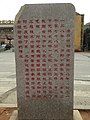
 Anping Bridge - seen from Shuitou - stelae - DSCF8937.JPG 2,848 × 2,136; 2.37 MB
-
 Anping Bridge - west end - DSCF9127.JPG 2,848 × 2,136; 2.37 MB
-
 Anping Bridge - west of Shuixin Ting - DSCF8983.JPG 2,848 × 2,136; 2.51 MB
-
 Anping Bridge - west of Shuixin Ting - DSCF8984.JPG 2,848 × 2,136; 2.47 MB
-
 Anping Bridge - west-central part - looking west - DSCF9094.JPG 2,848 × 2,136; 2.29 MB
-
 Anping Bridge - west-central part - looking west - DSCF9095.JPG 2,848 × 2,136; 2.38 MB
-
 Anping Bridge - west-central part - looking west - DSCF9098.JPG 2,848 × 2,136; 2.3 MB
-
 Anping Bridge - west-central part - looking west - DSCF9102.JPG 2,048 × 1,536; 1.36 MB
-
 Anping Bridge - west-central part - looking west - DSCF9103.JPG 2,048 × 1,536; 1.31 MB
-
 Anping Bridge - west-central part - looking west - DSCF9108.JPG 2,848 × 2,136; 2.43 MB
-
 Anping Bridge - west-central part - looking west - DSCF9110.JPG 2,048 × 1,536; 1.28 MB
-
 Anping Bridge - western section - DSCF8938.JPG 2,848 × 2,136; 2.33 MB
-
 Anping Bridge - western section - DSCF8939.JPG 2,848 × 2,136; 2.36 MB
-
 Anping Bridge - western section - DSCF8940.JPG 2,136 × 2,848; 2.44 MB
-
 Anping Bridge - western section - DSCF8941.JPG 2,848 × 2,136; 2.56 MB
-
 Anping Bridge - western section - DSCF8942.JPG 2,848 × 2,136; 2.29 MB
-
 Anping Bridge - western section - DSCF8944.JPG 2,848 × 2,136; 2.35 MB
-
 Anping Bridge - western section - DSCF8945.JPG 2,848 × 2,136; 2.31 MB
-
 Anping Bridge - western section - DSCF8946.JPG 2,848 × 2,136; 2.53 MB
-
 Anping Bridge - western section - DSCF8951.JPG 2,048 × 1,536; 1.27 MB
-
 Anping Bridge - western section - DSCF8952.JPG 2,848 × 2,136; 2.34 MB
-
 Anping Bridge - western section - DSCF8953.JPG 2,848 × 2,136; 2.3 MB
-
 Anping Bridge - western section - DSCF8954.JPG 2,848 × 2,136; 2.37 MB
-
 Anping Bridge - western section - DSCF8955.JPG 2,848 × 2,136; 2.5 MB
-
 Anping Bridge - western section - DSCF8956.JPG 2,136 × 2,848; 2.5 MB
-
 Anping Bridge - western section - DSCF8957.JPG 2,848 × 2,136; 2.51 MB
-
 Anping Bridge - western section - DSCF8958.JPG 2,848 × 2,136; 2.29 MB
-
 Anping Bridge - western section - DSCF8959.JPG 2,848 × 2,136; 2.44 MB
-
 Anping Bridge - western section - DSCF8960.JPG 2,848 × 2,136; 2.28 MB
-
 Anping Bridge - western section - DSCF8961.JPG 2,848 × 2,136; 2.4 MB
-
 Anping Bridge - western section - DSCF8965.JPG 2,848 × 2,136; 2.5 MB
-
 Anping Bridge - western section - DSCF8966.JPG 2,848 × 2,136; 2.36 MB
-
 Anping Bridge - western section - DSCF8969.JPG 2,848 × 2,136; 2.51 MB
-
 Anping Bridge - western section - DSCF8970.JPG 2,848 × 2,136; 2.37 MB
-
 Anping Bridge - western section - DSCF8971-cropped.JPG 2,842 × 406; 517 KB
-
 Anping Bridge - western section - DSCF8971.JPG 2,848 × 2,136; 2.43 MB
-
 Anping Bridge - western section - looking between the stones - DSCF8962.JPG 2,048 × 1,536; 1.3 MB
-
 Anping Bridge - western section - looking between the stones - DSCF8963.JPG 2,048 × 1,536; 1.35 MB
-
 Anping Bridge - western section - looking between the stones - DSCF8964.JPG 2,048 × 1,536; 1.35 MB
-
 Anping Bridge - western section - looking east - DSCF9114.JPG 2,848 × 2,136; 2.36 MB
-
 Anping Bridge - western section - looking to the ground - DSCF8972.JPG 2,848 × 2,136; 2.42 MB
-
 Anping Bridge - western section - looking to the ground - DSCF8973.JPG 2,848 × 2,136; 2.55 MB
-
 Anping Bridge - western section - looking west - DSCF8943.JPG 2,848 × 2,136; 2.35 MB
-
 Anping Bridge - western section - looking west - DSCF9115.JPG 2,848 × 2,136; 2.37 MB
-
 Anping Bridge - western section - looking west - DSCF9116.JPG 2,848 × 2,136; 2.41 MB
-
 Anping Bridge - western section - surface - DSCF8967.JPG 2,848 × 2,136; 2.58 MB
-
 Anping Bridge - western section - surface - DSCF8968.JPG 2,848 × 2,136; 2.53 MB
-
 Anping Bridge 2017-01-28.jpg 1,280 × 960; 317 KB
-
 Anping Qiao 2012.02.28 15-44-02.jpg 4,752 × 3,168; 5.93 MB
-
 Anping Qiao 2012.02.28 15-44-47.jpg 4,752 × 3,168; 5.2 MB
-
 Anping Qiao 2012.02.28 15-45-11.jpg 4,752 × 3,168; 5.69 MB
-
 Anping Qiao 2012.02.28 15-45-41.jpg 3,168 × 4,752; 2.55 MB
-
 Anping Qiao 2012.02.28 15-46-18.jpg 4,752 × 3,168; 5.91 MB
-
 Anping Qiao 2012.02.28 15-46-59.jpg 4,752 × 3,168; 7.43 MB
-
 Anping Qiao 2012.02.28 15-47-12.jpg 4,752 × 3,168; 6.38 MB
-
 Anping Qiao 2012.02.28 15-47-49.jpg 3,168 × 4,752; 5.76 MB
-
 Anping Qiao 2012.02.28 15-48-26.jpg 3,168 × 4,752; 7.52 MB
-
 Anping Qiao 2012.02.28 15-50-26.jpg 4,752 × 3,168; 5.22 MB
-
 Anping Qiao 2012.02.28 15-51-48.jpg 3,168 × 4,752; 5.67 MB
-
 Anping Qiao 2012.02.28 15-53-39.jpg 3,168 × 4,752; 2.25 MB
-
 Anping Qiao 2012.02.28 15-54-20.jpg 4,752 × 3,168; 6.27 MB
-
 Anping Qiao 2012.02.28 15-55-48.jpg 3,168 × 4,752; 3.37 MB
-
 Anping Qiao 2012.02.28 15-57-39.jpg 3,168 × 4,752; 3.03 MB
-
 Anping Qiao 2012.02.28 15-59-53.jpg 4,752 × 3,168; 5.53 MB
-
 Anping Qiao 2012.02.28 16-01-49.jpg 4,752 × 3,168; 6.21 MB
-
 Anping Qiao 2012.02.28 16-04-52.jpg 4,752 × 3,168; 5.93 MB
-
 Anping Qiao 2012.02.28 16-07-54.jpg 4,752 × 3,168; 6.82 MB
-
 Anping Qiao 2012.02.28 16-10-04.jpg 4,752 × 3,168; 5.3 MB
-
 Anping Qiao 2012.02.28 16-11-19.jpg 3,168 × 4,752; 3.22 MB
-
 Anping Qiao 2012.02.28 16-12-37.jpg 4,752 × 3,168; 7.21 MB
-
 Anping Qiao 2012.02.28 16-13-19.jpg 3,168 × 4,752; 1.76 MB
-
 Anping Qiao 2012.02.28 16-16-03.jpg 4,752 × 3,168; 6.45 MB
-
 Anping Qiao 2012.02.28 16-17-49.jpg 3,168 × 4,752; 3.08 MB
-
 Anping Qiao 2012.02.28 16-17-58.jpg 4,752 × 3,168; 7.31 MB
-
 Anping Qiao 2012.02.28 16-19-01.jpg 3,168 × 4,752; 2.65 MB
-
 Anping Qiao 2012.02.28 16-21-17.jpg 4,752 × 3,168; 5.59 MB
-
 Anping Qiao 2012.02.28 16-24-35.jpg 4,752 × 3,168; 6.21 MB
-
 Anping Qiao 2012.02.28 16-26-43.jpg 4,752 × 3,168; 5.93 MB
-
 Anping Qiao 2012.02.28 16-27-32.jpg 4,752 × 3,168; 6.73 MB
-
 Anping Qiao 2012.02.28 16-28-15.jpg 3,168 × 4,752; 6.93 MB
-
 Anping Qiao 2012.02.28 16-30-09.jpg 4,752 × 3,168; 5.6 MB
-
 安平桥 01.jpg 2,448 × 3,264; 3.15 MB
-
 安平桥 02.jpg 2,448 × 3,264; 2.91 MB
-
 安平桥 03.jpg 2,448 × 3,264; 3.05 MB
-
 安平桥 04.jpg 3,264 × 2,448; 2.73 MB
-
 安平桥晋江段东向.jpg 4,000 × 2,664; 4.2 MB
-
 安海鎮的安平橋.JPG 768 × 1,024; 529 KB


Categories:
- Stone bridges of the Southern Song Dynasty
- Bridges in Quanzhou
- Bridges in Fujian by name
- Anhai
- Shuitou, Nan'an, Fujian
- Shijing River
- Bridges completed in 1151
- Built in China in 1151
- Major National Historical and Cultural Sites in Fujian
- Southern Min architecture
- Quanzhou: Emporium of the World in Song-Yuan China