Category:Ancien cimetière de Céligny
Jump to navigation
Jump to search
| Object location | | View all coordinates using: OpenStreetMap |
|---|
Graveyard in the canton of Geneva, Switzerland   | |||||
| Upload media | |||||
| Instance of | |||||
|---|---|---|---|---|---|
| Location | Céligny, Canton of Geneva, Switzerland | ||||
| Street address |
| ||||
| Inception |
| ||||
| Different from | |||||
| official website | |||||
 | |||||
Media in category "Ancien cimetière de Céligny"
The following 38 files are in this category, out of 38 total.
-
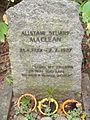 Alistair Maclean grave.jpg 2,304 × 3,072; 3.53 MB
-
 Ancien cimetière Céligny-Calame-Bordier.jpg 1,024 × 768; 417 KB
-
 Ancien cimetière Céligny-portail.jpg 1,024 × 768; 303 KB
-
 Ancien cimetière Céligny-tombe Bordier-détail 1.jpg 386 × 942; 160 KB
-
 Ancien cimetière Céligny-tombe Bordier-détail 2.jpg 1,174 × 1,946; 720 KB
-
 Ancien cimetière Céligny-tombe Bordier.jpg 270 × 710; 128 KB
-
 Ancien cimetière Céligny-tombe Calame.jpg 1,024 × 768; 306 KB
-
 Ancien cimetière Céligny.jpg 1,024 × 768; 455 KB
-
 Ancien cimetière de Céligny 111.jpg 4,128 × 2,322; 6.03 MB
-
 Ancien cimetière de Céligny.jpg 4,128 × 2,322; 5.78 MB
-
 Gate-OldCemeteryOfCeligny RomanDeckert22122021-02.jpg 4,544 × 3,392; 13.95 MB
-
 Gate-OldCemeteryOfCeligny RomanDeckert22122021.jpg 5,104 × 2,904; 11.85 MB
-
 Grave-FamilleDeCharmant-OldCemeteryOfCeligny RomanDeckert22122021.jpg 5,152 × 2,904; 12.78 MB
-
 Grave-RichardBurton-VieuxCimetiereDeCeligny RomanDeckert27062021.jpg 3,905 × 2,899; 12.35 MB
-
 GraveAlistair-GiselaMacLean-OldCemeteryOfCeligny RomanDeckert22122021.jpg 5,152 × 2,904; 12.28 MB
-
 GraveAlistairMacLean-OldCemeteryOfCeligny RomanDeckert22122021.jpg 4,928 × 3,288; 12.63 MB
-
 GraveRichardBurton-OldCemeteryOfCeligny RomanDeckert22122021-02.jpg 5,152 × 2,904; 12.01 MB
-
 GraveRichardBurton-OldCemeteryOfCeligny RomanDeckert22122021-03.jpg 5,152 × 2,904; 12.04 MB
-
 GraveRichardBurton-OldCemeteryOfCeligny RomanDeckert22122021.jpg 5,152 × 2,904; 12.93 MB
-
 Graves-CheneviereFamily-OldCemeteryOfCeligny RomanDeckert22122021.jpg 4,928 × 3,288; 13.47 MB
-
 Graves-FernandCheneviere-WandaCheneviereClaparede-OldCemeteryOfCeligny RomanDeckert22122021.jpg 4,928 × 3,288; 12.98 MB
-
 Graves-FernandCheneviere-WandaCheneviereClaparede-OldCemeteryOfCeligny RomanDeckert27062021.jpg 4,000 × 3,000; 11.43 MB
-
 Graves-PingBordier-AndreBordier-OldCemeteryOfCeligny RomanDeckert22122021-01.jpg 5,040 × 2,840; 14.03 MB
-
 Graves-PingBordier-AndreBordier-OldCemeteryOfCeligny RomanDeckert22122021-02.jpg 4,840 × 3,248; 14.95 MB
-
 Graves-PingBordier-AndreBordier-OldCemeteryOfCeligny RomanDeckert22122021-03.jpg 4,872 × 3,168; 15.21 MB
-
 Graves-PingBordier-AndreBordier-OldCemeteryOfCeligny RomanDeckert27062021.jpg 3,988 × 2,992; 11.49 MB
-
 Gravestones-Edmond-MargueriteCheneviere-OldCemeteryOfCeligny RomanDeckert22122021.jpg 4,928 × 3,288; 13.38 MB
-
 OldCemeteryOfCeligny RomanDeckert22122021-01.jpg 5,152 × 2,904; 11.31 MB
-
 OldCemeteryOfCeligny RomanDeckert22122021-02.jpg 5,152 × 2,904; 12.01 MB
-
 OldCemeteryOfCeligny RomanDeckert22122021-03.jpg 4,888 × 2,904; 11.58 MB
-
 OldCemeteryOfCeligny RomanDeckert22122021-04.jpg 4,824 × 3,288; 12.63 MB
-
 OldCemeteryOfCeligny RomanDeckert22122021-05.jpg 5,152 × 2,904; 12.09 MB
-
 OldCemeteryOfCeligny RomanDeckert22122021-06.jpg 5,152 × 2,904; 12.27 MB
-
 OldCemeteryOfCeligny RomanDeckert27062021-01.jpg 4,000 × 3,000; 9.38 MB
-
 OldCemeteryOfCeligny RomanDeckert27062021-02.jpg 4,000 × 3,000; 10.07 MB
-
 OldCemeteryOfCeligny RomanDeckert27062021-03.jpg 4,000 × 3,000; 10.59 MB
-
 Richard Burton grave in CH 01.jpg 2,322 × 4,128; 5.31 MB
-
 Richard Burton grave.jpg 2,304 × 3,072; 3.54 MB


