Category:Altes Primarschulhaus (Stettfurt)
Jump to navigation
Jump to search
| Object location | | View all coordinates using: OpenStreetMap |
|---|
|
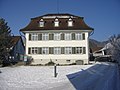
This is a category about a cultural property of regional significance in Switzerland with KGS number 11056
|
school building in Stettfurt in the canton of Thurgau, Switzerland  | |||||
| Upload media | |||||
| Instance of | |||||
|---|---|---|---|---|---|
| Part of | |||||
| Location |
| ||||
| Street address |
| ||||
| Heritage designation |
| ||||
 | |||||
Media in category "Altes Primarschulhaus (Stettfurt)"
The following 3 files are in this category, out of 3 total.
-
 KäsereistrStettfurtIII.jpg 2,816 × 2,112; 2.76 MB
-
 KäsereistrStettfurtIV.jpg 2,816 × 2,112; 2.68 MB
-
 KäsereistrStettfurtV.jpg 2,816 × 2,112; 2.86 MB

