Category:Al-Khayriyya
Jump to navigation
Jump to search
Palestinian village in Jaffa district, replaced by the Jewish Hiriya landfill .JPG) | |||||
| Upload media | |||||
| Instance of | |||||
|---|---|---|---|---|---|
| Area |
| ||||
 | |||||
Media in category "Al-Khayriyya"
The following 18 files are in this category, out of 18 total.
-
 Bat Yam 1945.jpg 890 × 685; 349 KB
-
 Al-Khayriyya (1).JPG 4,608 × 3,456; 3.61 MB
-
 Al-Khayriyya (2).JPG 4,608 × 3,456; 3.96 MB
-
 Al-Khayriyya (3).JPG 4,608 × 3,456; 3.35 MB
-
 Al-Khayriyya (4).JPG 4,608 × 3,456; 3.92 MB
-
 Al-Khayriyya.JPG 4,608 × 3,456; 3.15 MB
-
 El Kheiriye cropped copy.jpg 1,461 × 1,330; 575 KB
-
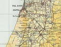
 Historical map series for the area of al-Khayriyya (1870s).jpg 740 × 744; 143 KB
-
-
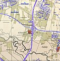
 Historical map series for the area of al-Khayriyya (1940s).jpg 740 × 744; 237 KB
-
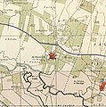
 Historical map series for the area of al-Khayriyya (modern).jpg 740 × 744; 140 KB
-
 Landfill, where once stood the village Benei Barak.jpg 4,000 × 3,000; 4.75 MB
-
 Near old ruin of Benei Barak.jpg 4,000 × 3,000; 4.5 MB
-
 PikiWiki Israel 68753 an abandoned building on the side of highway 461.jpg 4,096 × 2,306; 2.53 MB
-
 PikiWiki Israel 68754 an abandoned building on the side of highway 461.jpg 2,787 × 1,750; 1.75 MB
-
 PikiWiki Israel 68755 an abandoned building on the side of highway 461.jpg 2,363 × 1,835; 1.72 MB
-
 PikiWiki Israel 68756 an abandoned building on the side of highway 461.jpg 2,564 × 2,328; 1.55 MB
-
 Salame cropped.jpg 4,674 × 2,925; 3.57 MB

.JPG)
.JPG)
.JPG)


.jpg)
.jpg)
.jpg)
.jpg)


