Category:Air Line bridge over the Quinebaug River
Jump to navigation
Jump to search
| Object location | | View all coordinates using: OpenStreetMap |
|---|
Media in category "Air Line bridge over the Quinebaug River"
The following 6 files are in this category, out of 6 total.
-
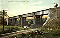 Air Line bridge at Putnam postcard.jpg 1,600 × 1,022; 288 KB
-
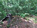 Buffer at former Quinebaug River bridge, July 2013.JPG 4,320 × 3,240; 4.86 MB
-
 North abutment of Quinebaug River bridge (1), July 2013.JPG 4,320 × 3,240; 4 MB
-
 North abutment of Quinebaug River bridge (2), July 2013.JPG 4,320 × 3,240; 4.16 MB
-
 Quinebaug River footbridge from abutment, July 2013.JPG 3,812 × 2,833; 2.72 MB
-
 Quinebaug River footbridge, July 2013.JPG 4,320 × 3,240; 4.95 MB


,_July_2013.JPG)
,_July_2013.JPG)

