Category:Aerial photographs of volcanoes in New Zealand
Jump to navigation
Jump to search
Subcategories
This category has the following 2 subcategories, out of 2 total.
Media in category "Aerial photographs of volcanoes in New Zealand"
The following 10 files are in this category, out of 10 total.
-
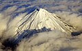 Clouds around Mount Taranaki.jpg 1,231 × 774; 857 KB
-
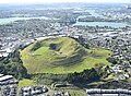
 Mt Roskill 2018.jpg 3,216 × 2,144; 1.41 MB
-
 Mt Wellington 2018.jpg 5,124 × 3,767; 13.12 MB
-
 One Tree Hill 2018.jpg 1,417 × 945; 1.39 MB
-
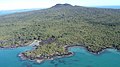
 Onepoto 2009.jpg 3,200 × 1,800; 3.4 MB
-
 Rangitoto09f.jpg 3,200 × 1,800; 2.85 MB
-
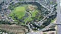
 Sturges Park 2018.jpg 6,000 × 4,000; 6.52 MB
-
 Te Kawa hill and Kakepuku from air looking west.jpg 1,903 × 2,392; 893 KB
-
 Whakaari - White Island Volcano in New Zealand 20061112 B.jpg 3,008 × 2,000; 3.88 MB
-
 WhakarewarewaAerial.jpg 1,536 × 1,024; 648 KB


