Category:Aerial photographs of lakes of Germany
Jump to navigation
Jump to search
Countries of Europe: Austria · Croatia · Finland · Germany · Hungary · Italy · Poland · Portugal‡ · Russia‡ · Switzerland · Turkey‡
‡: partly located in Europe
‡: partly located in Europe
Federal states of Germany:
Subcategories
This category has the following 18 subcategories, out of 18 total.
Media in category "Aerial photographs of lakes of Germany"
The following 173 files are in this category, out of 173 total.
-
 Aerial image of Altmühlsee (view from the southeast).jpg 5,300 × 3,200; 5.8 MB
-
 Aerial image of Ampersee (view from the south).jpg 3,900 × 2,200; 4.63 MB
-
 Aerial image of Badenburg Lake (view from the south).jpg 3,800 × 2,200; 5.65 MB
-
 Aerial image of Bansee (view from the south).jpg 3,700 × 2,300; 5.04 MB
-
 Aerial image of Blassee (view from the southwest).jpg 3,200 × 2,200; 4.98 MB
-
 Aerial image of Brunnensee (view from the southeast).jpg 3,300 × 2,000; 4.12 MB
-
 Aerial image of Ebersberger Weiherkette (view from the southeast).jpg 3,800 × 2,000; 4.51 MB
-
 Aerial image of Egglburger See (view from the southeast).jpg 3,600 × 2,300; 3.93 MB
-
 Aerial image of Einbessee (view from the south).jpg 3,300 × 2,000; 4.24 MB
-
 Aerial image of Eschenauer See (view from the south).jpg 3,500 × 2,200; 3.68 MB
-
 Aerial image of Fasaneriesee (view from the south).jpg 5,300 × 3,000; 8.95 MB
-
 Aerial image of Feldmochinger See (view from the southwest).jpg 4,000 × 2,800; 6.8 MB
-
 Aerial image of Friedberger Baggersee (view from the southeast).jpg 5,000 × 3,000; 6.57 MB
-
 Aerial image of Garchinger See.jpg 3,800 × 2,000; 4.38 MB
-
 Aerial image of Griessee (view from the southeast).jpg 3,700 × 2,200; 5.57 MB
-
 Aerial image of Großer Alpsee (view from the northeast).jpg 4,900 × 3,200; 7.65 MB
-
 Aerial image of Großer Brombachsee (view from the southeast).jpg 5,200 × 3,100; 6.28 MB
-
 Aerial image of Großer Kesselsee (view from the southwest).jpg 3,300 × 2,100; 4.43 MB
-
 Aerial image of Grüntensee (view from the southwest).jpg 4,200 × 2,800; 6.29 MB
-
 Aerial image of Hackensee (view from the southwest).jpg 3,800 × 2,200; 5.66 MB
-
 Aerial image of Happurger See (view from the west).jpg 5,200 × 3,100; 7.25 MB
-
 Aerial image of Hartsee (view from the south).jpg 3,400 × 2,400; 4.47 MB
-
 Aerial image of Hochmoor am Kesselsee (view from the southwest).jpg 3,700 × 2,300; 6.16 MB
-
 Aerial image of Hofsee and Katzensee (view from the southwest).jpg 3,700 × 2,300; 4.47 MB
-
 Aerial image of Hofstätter See (view from the south).jpg 4,000 × 1,800; 3.76 MB
-
 Aerial image of Hollerner See.jpg 3,900 × 2,600; 4.91 MB
-
 Aerial image of Igelsbachsee (view from the southeast).jpg 5,500 × 3,500; 9.33 MB
-
 Aerial image of Karlsfelder See.jpg 3,400 × 2,700; 4.33 MB
-
 Aerial image of Kastenseeoner See (view from the southeast).jpg 3,700 × 2,200; 4.9 MB
-
 Aerial image of Kautsee (view from the south).jpg 3,396 × 2,400; 5.63 MB
-
 Aerial image of Kirchsee in Oberbayern (view from the south).jpg 3,900 × 2,100; 4.78 MB
-
 Aerial image of Kleinhesseloher See.jpg 5,568 × 3,712; 7.47 MB
-
 Aerial image of Lake Simssee (view from the southwest).jpg 5,300 × 3,600; 8.77 MB
-
 Aerial image of Langbürgner See (view from the southwest).jpg 4,200 × 2,300; 5.71 MB
-
 Aerial image of Laubensee (view from the south).jpg 3,600 × 2,200; 3.32 MB
-
 Aerial image of Lerchenauer See (view from the south).jpg 4,000 × 3,300; 8.04 MB
-
 Aerial image of Liebensteinspeicher (view from the west).jpg 5,100 × 3,300; 8.84 MB
-
 Aerial image of Liensee (view from the west).jpg 3,200 × 2,300; 4.5 MB
-
 Aerial image of Mallertshofer See.jpg 3,500 × 2,400; 4.76 MB
-
 Aerial image of Markkleeberger See.jpg 5,560 × 2,580; 3.32 MB
-
 Aerial image of Niedersonthofener See (view from the east).jpg 5,100 × 3,100; 7.35 MB
-
 Aerial image of Oberschleißheim Regatta Course (view from the southwest).jpg 4,600 × 3,400; 6.49 MB
-
 Aerial image of Olchinger See (view from the southwest).jpg 3,600 × 2,200; 4.78 MB
-
 Aerial image of Pelhamer See (view from the southwest).jpg 3,600 × 2,400; 4.72 MB
-
 Aerial image of Regattaparksee (view from the northwest).jpg 5,000 × 3,300; 5.62 MB
-
 Aerial image of Rinssee (view from the south).jpg 3,900 × 2,200; 4.02 MB
-
 Aerial image of Rottachsee (view from the southwest).jpg 5,200 × 2,600; 5.71 MB
-
 Aerial image of Schloßsee (view from the southwest).jpg 3,000 × 2,400; 3.98 MB
-
 Aerial image of Seeleitensee, Mittersee, and Jägersee (view from the south).jpg 3,800 × 2,200; 4.61 MB
-
 Aerial image of Seeon.jpg 5,320 × 2,580; 4.33 MB
-
 Aerial image of Siferlinger See (view from the south).jpg 3,600 × 2,400; 4.3 MB
-
 Aerial image of Soyensee (view from the southwest).jpg 3,800 × 2,100; 3.85 MB
-
 Aerial image of Staudhamer See (view from the south).jpg 3,700 × 2,000; 3.84 MB
-
 Aerial image of Steinsee in Niederseeon (view from the south).jpg 3,200 × 2,200; 3.7 MB
-
 Aerial image of Stettner See (view from the south).jpg 3,600 × 2,200; 4.55 MB
-
 Aerial image of Thaler See (view from the southwest).jpg 3,300 × 2,400; 4.63 MB
-
 Aerial image of the Alatsee (view from the southwest).jpg 4,400 × 3,300; 7.95 MB
-
 Aerial image of the Alpsee (view from the southwest).jpg 5,200 × 3,200; 6.18 MB
-
 Aerial image of the Chiemsee (view from the southwest).jpg 5,500 × 2,600; 4.66 MB
-
 Aerial image of the Chiemsee municipality.jpg 5,568 × 3,712; 4.68 MB
-
 Aerial image of the Eggstätt-Hemhof Lakes (view from the southwest).jpg 5,000 × 3,600; 8.37 MB
-
 Aerial image of the Eggstätt-Hemhof Lakes.jpg 5,400 × 3,400; 4.52 MB
-
 Aerial image of the Forggensee (view from the southwest).jpg 5,000 × 3,500; 5.89 MB
-
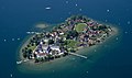 Aerial image of the Fraueninsel.jpg 5,400 × 3,200; 4.61 MB
-
 Aerial image of the Froschhauser See (view from the southeast).jpg 5,500 × 3,500; 5.83 MB
-
 Aerial image of the Hopfensee (view from the south).jpg 5,300 × 2,600; 5.24 MB
-
 Aerial image of the Ismaning Reservoir (view from the southeast).jpg 5,300 × 2,600; 5.34 MB
-
 Aerial image of the Kochelsee (view from the south).jpg 5,500 × 3,200; 6.47 MB
-
 Aerial image of the Langwieder lake district (view from the south).jpg 4,000 × 2,400; 5.84 MB
-
 Aerial image of the Obinger See (view from the west).jpg 4,800 × 3,400; 6.36 MB
-
 Aerial image of the Pilsensee (view from the southwest).jpg 5,300 × 2,700; 5.48 MB
-
 Aerial image of the Riegsee (view from the south).jpg 4,800 × 3,200; 4.71 MB
-
 Aerial image of the Schliersee (view from the south).jpg 5,200 × 3,600; 8.06 MB
-
 Aerial image of the Schwansee (view from the southwest).jpg 5,500 × 3,300; 8.05 MB
-
 Aerial image of the Seehamer See (view from the west).jpg 4,300 × 3,500; 5.85 MB
-
 Aerial image of the Seeon Lakes.jpg 5,460 × 3,560; 6.22 MB
-
 Aerial image of the Staffelsee (view from the southeast).jpg 5,300 × 3,400; 6.53 MB
-
 Aerial image of the Staffelsee.jpg 5,250 × 3,000; 4.09 MB
-
 Aerial image of the Tachinger See (view from the south).jpg 5,400 × 3,200; 5.24 MB
-
 Aerial image of the Tegernsee (view from the southeast).jpg 5,400 × 3,500; 7.61 MB
-
 Aerial image of the Waginger See (view from the southeast).jpg 5,000 × 3,600; 5.87 MB
-
 Aerial image of the Waginger See and Tachinger See (view from the southeast).jpg 4,400 × 3,500; 5.33 MB
-
 Aerial image of the Walchensee (view from the southeast).jpg 5,400 × 3,300; 6.74 MB
-
 Aerial image of the Walchensee (view from the southwest).jpg 5,300 × 3,500; 6.74 MB
-
 Aerial image of the Weißensee (view from the southeast).jpg 4,700 × 3,500; 6.58 MB
-
 Aerial image of the Wörth island, Staffelsee (view from the southwest).jpg 5,300 × 3,700; 7.4 MB
-
 Aerial image of the Wörthsee (view from the southwest).jpg 5,200 × 2,900; 5.62 MB
-
 Aerial image of Unterschleißheimer See.jpg 3,900 × 2,500; 5.94 MB
-
 Aerial image of Waldschwaigsee (view from the southeast).jpg 3,700 × 2,200; 4.56 MB
-
 Aerial image of Zillhamer See and Ameranger See (view from the south).jpg 3,700 × 2,400; 4.63 MB
-
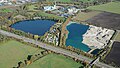
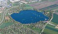
 Aerial view of the lake and sand beach at Otto-Maigler-See in Hürth, Germany (48331367942).jpg 5,464 × 3,640; 12.75 MB
-
 Aerial view of the lake Hürther Waldsee (Theresiasee) in Hürth, Germany (48331225141).jpg 5,464 × 3,640; 14.48 MB
-
 Aerials Bavaria 16.06.2006 12-03-19.jpg 1,965 × 1,473; 1.82 MB
-
 Allner-013.jpg 3,648 × 2,736; 5.65 MB
-
 Altlandsberg asv2022-09 img16 Wilkendorf Luftbild.jpg 5,464 × 3,640; 16.91 MB
-
 Atzenhof Trausnitz 2009.JPG 3,008 × 2,000; 1.23 MB
-
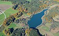
 Bad Wünnenberg Aabachsee Sauerland-Ost 246.jpg 4,256 × 2,832; 9.82 MB
-
 Bad Wünnenberg Aabachsee Sauerland-Ost 247.jpg 4,256 × 2,832; 10.1 MB
-
 Bad Wünnenberg Aabachsee Sauerland-Ost 248.jpg 3,589 × 2,388; 7.41 MB
-
 Bad Wünnenberg Aabachsee Sauerland-Ost 249.jpg 4,256 × 2,832; 9.9 MB
-
 Bad Wünnenberg Aabachsee Sauerland-Ost 250.jpg 4,256 × 2,832; 11.34 MB
-
 Bad Wünnenberg Aabachsee Sauerland-Ost 251.jpg 4,256 × 2,832; 11.22 MB
-
 Bad Wünnenberg Aabachsee Sauerland-Ost 261.jpg 4,256 × 2,832; 9.73 MB
-
 Bad Wünnenberg Aabachsee Sauerland-Ost 262.jpg 4,256 × 2,832; 8.75 MB
-
 Bannwaldsee von Nordwesten.JPG 1,853 × 2,310; 1.36 MB
-
 Bantikower See, Luftaufnahme (2014).JPG 4,032 × 2,272; 4.6 MB
-
 Berlin Alboinplatz Blanke Helle UAV 05-2017.jpg 4,095 × 2,730; 5.94 MB
-
 Berlin Arkenberger Baggersee asv2022-07 img1.jpg 5,125 × 3,203; 10.17 MB
-
 Berlin Arkenberger Baggersee asv2022-07 img2.jpg 5,171 × 3,447; 12.13 MB
-
 Berlin Arkenberger Baggersee und Aussenring asv2022-07.jpg 5,356 × 3,013; 11.36 MB
-
 Berlin Gehrensee asv2022-07 img1.jpg 4,520 × 2,825; 12.65 MB
-
 Berlin Gehrensee asv2022-07 img2.jpg 4,581 × 3,436; 15.33 MB
-
 Berlin Halensee in Grunewald UAV 04-2017.jpg 4,808 × 3,203; 7.05 MB
-
 Berlin Schlachtensee asv2022-08 img1.jpg 5,078 × 3,174; 10.36 MB
-
 Berlin Schlachtensee asv2022-08 img2.jpg 5,464 × 3,415; 12.3 MB
-
 Berlin Volkspark Friedrichshain 09-2017 img3.jpg 4,590 × 3,058; 5.87 MB
-
 Berlin-Wannsee Betriebswerk Luftbild asv2022-09.jpg 4,767 × 3,575; 15.12 MB
-
 Blick auf den nördlichen Bereich vom Otto-Maigler-See in Hürth, Deutschland (48331223481).jpg 5,464 × 3,640; 13.38 MB
-
 BRBHavel asv2022-07 img19 Gördensee.jpg 5,140 × 3,213; 9.72 MB
-
 Eulenberg.jpg 3,648 × 2,736; 5.36 MB
-
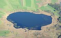
 Funtensee Orthophoto.jpg 1,256 × 1,124; 562 KB
-
 Grossräschener See 002.JPG 4,032 × 2,272; 4.8 MB
-
 Großdubrau Blaue Adria Aerial Pan.jpg 9,833 × 3,910; 29.83 MB
-
 Großdubrau Blaue Adria Aerial.jpg 3,909 × 2,077; 6.33 MB
-
 Großdubrau Crosta Aerial Pan.jpg 8,861 × 3,506; 22.93 MB
-
 Großdubrau Crosta Aerial.jpg 3,889 × 2,077; 5.81 MB
-
 Gruentensee de.jpg 850 × 721; 500 KB
-
 Görlitz Berzdorfer See Luftbild.jpg 3,900 × 2,600; 11.22 MB
-
 Gülper See.jpg 3,648 × 2,736; 4.58 MB
-
 AussenalsterLuft1.jpg 1,573 × 1,180; 385 KB
-
 Hennef-Allner, A560.jpg 3,648 × 2,736; 5.89 MB
-
 Hennef-Dondorfer See 115.JPG 6,016 × 3,384; 8.72 MB
-
 HerzbergAmHarz asv2022-06 img02.jpg 5,464 × 3,640; 9.53 MB
-
 HerzbergAmHarz asv2022-06 img03.jpg 5,464 × 3,640; 9.65 MB
-
 HerzbergAmHarz asv2022-06 img05.jpg 4,267 × 3,556; 8.89 MB
-
 HerzbergAmHarz asv2022-06 img06.jpg 4,405 × 3,524; 9.36 MB
-
 HerzbergAmHarz asv2022-06 img07.jpg 4,550 × 3,640; 8.18 MB
-
 Himberger See 003.jpg 6,016 × 3,384; 10.76 MB
-
 Härtsfeldsee 001.jpg 6,016 × 3,384; 8.32 MB
-
 KLG 0164 Altdöberner See.jpg 6,016 × 3,384; 6.41 MB
-
 KLG 0305 Berzdorfer See.jpg 6,016 × 3,384; 6.72 MB
-
 Krumme Lanke B-Zehlendorf 06-2017.jpg 5,082 × 3,385; 7.7 MB
-
 Luftaufnahme Seeshaupt mit Kirche.jpg 1,500 × 1,000; 259 KB
-
 Luftbild vom Hürther Waldsee (Theresiasee) in Hürth, Deutschland (48331227316).jpg 5,464 × 3,070; 12.65 MB
-
 Müllrose asv2022-08 img1 Kleiner und Grosser See.jpg 5,340 × 3,560; 12.3 MB
-
 Müllrose asv2022-08 img2 Kleiner See.jpg 3,415 × 2,732; 8.22 MB
-
 Müllrose asv2022-08 img3 Grosser See.jpg 5,274 × 3,516; 14.35 MB
-
 Müllrose asv2022-08 img4 Grosser See.jpg 5,255 × 3,503; 13.61 MB
-
 Neffelsee 002x.jpg 6,016 × 3,384; 8.59 MB
-
 OderteichLuftbild.jpg 2,430 × 1,637; 3.28 MB
-
 OderteichLuftbild1.jpg 2,804 × 2,195; 3.77 MB
-
 PM Caputh asv2018-06 img01.jpg 5,464 × 3,640; 9.14 MB
-
 Rüdersdorf asv2022-06 img3 Stienitzsee.jpg 4,119 × 3,295; 8.91 MB
-
 Rügen asv2022-08 img44 Binz Luftbild Schmachter See.jpg 5,200 × 3,250; 9.51 MB
-
 Germany schwerin aerial view ArM.jpg 2,545 × 1,849; 4.01 MB
-
 Stahnsdorf Gueterfelder See asv2018-05.jpg 5,378 × 3,361; 7.23 MB
-
 Stausee der Lechstaustufe 6 (südlicher Teil).jpg 1,183 × 867; 427 KB
-
 Stoessensee B-Westend 07-2017 img1.jpg 4,570 × 3,047; 6.1 MB
-
 Stoessensee B-Westend 07-2017 img2.jpg 4,347 × 2,898; 5.58 MB
-
 Stoessensee B-Westend 07-2017 img3.jpg 4,209 × 3,157; 5 MB
-
 Talsperre Döllnitzsee 001.jpg 6,016 × 3,384; 5.96 MB
-
 Tegernsee Aerial 1.jpg 4,896 × 3,672; 5.22 MB
-
 Tegernsee Aerial 2.jpg 4,896 × 3,672; 5.35 MB
-
 Tegernsee aerial.jpg 5,184 × 3,456; 8.44 MB
-
 Tegernsee II.jpg 1,000 × 547; 82 KB
-
 Unter- Oberuckersee Potzlower See aerial.jpg 2,112 × 2,816; 3.48 MB
-
 Unteruckersee aerial.jpg 2,816 × 1,428; 2.44 MB
-
 Weisser See B-Weissensee 06-2017.jpg 4,144 × 2,763; 5.69 MB
-
 Werneuchen asv2022-08 img07 Haussee Seefeld-Löhme.jpg 5,058 × 3,372; 10.53 MB
-
 Werneuchen asv2022-08 img10 Haussee Seefeld-Löhme.jpg 5,114 × 3,409; 16.07 MB
-
 Wöhrsee Orthophoto.jpg 1,412 × 1,295; 674 KB
-
 Zwenkauer See 001.jpg 6,016 × 3,384; 3.99 MB
-
 Zülpicher See 002x.jpg 6,016 × 3,384; 7.22 MB
.jpg)
.jpg)
.jpg)
.jpg)
.jpg)
.jpg)
.jpg)
.jpg)
.jpg)
.jpg)
.jpg)
.jpg)
.jpg)

.jpg)
.jpg)
.jpg)
.jpg)
.jpg)
.jpg)
.jpg)
.jpg)
.jpg)
.jpg)
.jpg)

.jpg)

.jpg)
.jpg)
.jpg)

.jpg)
.jpg)
.jpg)
.jpg)
.jpg)
.jpg)


.jpg)
.jpg)
.jpg)
.jpg)
.jpg)
.jpg)
.jpg)
.jpg)
.jpg)

.jpg)
.jpg)
.jpg)
.jpg)
.jpg)
.jpg)
.jpg)
.jpg)
.jpg)

.jpg)

.jpg)

.jpg)
.jpg)
.jpg)
.jpg)
.jpg)
.jpg)
.jpg)
.jpg)
.jpg)
.jpg)
.jpg)

.jpg)

.jpg)
.jpg)
.jpg)
.jpg)
.jpg)
.jpg)
.jpg)
.jpg)
.jpg)

.jpg)
.jpg)
.jpg)
_in_H%C3%BCrth,_Germany_(48331225141).jpg)


.JPG)


.jpg)


_in_H%C3%BCrth,_Deutschland_(48331227316).jpg)


.jpg)


