Category:Aerial photographs of Upper Bavaria
Jump to navigation
Jump to search
Deutsch: Luftaufnahmen aus dem Regierungsbezirk Oberbayern.
Subcategories
This category has the following 22 subcategories, out of 22 total.
Media in category "Aerial photographs of Upper Bavaria"
The following 16 files are in this category, out of 16 total.
-
 Aerial photograph of Raisting.jpg 3,648 × 2,432; 2.4 MB
-
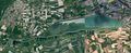
 Aerial View of the frozen Geroldsee(146415349).jpg 2,048 × 1,535; 608 KB
-
 Justizvollzugsanstalt Bernau (Luftbild).jpg 1,725 × 1,235; 216 KB
-
 ETH-BIB-Fürstenfeldbruck-Inlandflüge-LBS MH01-003986.tif 6,412 × 4,493; 82.54 MB
-
 ETH-BIB-Fürstenfeldbruck-Inlandflüge-LBS MH01-003987.tif 6,445 × 4,483; 82.78 MB
-
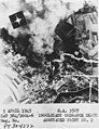 IN-5-4-45-US.jpg 1,250 × 1,621; 393 KB
-
 Ingolstadt Raffinerie Aerial.jpg 969 × 727; 291 KB
-
 Luftbild - Ingolstadt - Luitpoldpark - 1945.jpg 2,560 × 1,371; 552 KB
-
 Luftbild Kläranlage Amperverband.jpg 3,648 × 2,432; 2.18 MB
-
 Manching Airport.jpg 1,095 × 822; 883 KB
-
 München Panorama Ballon 1918.jpg 5,000 × 332; 752 KB
-
 Schörghuber Unternehmensportrait 2018 Bild 1.jpg 5,464 × 3,070; 7.98 MB
-
 Speichersee Ismaning dop200.png 1,391 × 568; 1.43 MB
-
 Taubensee-Kössen-Unterwössen Orthofoto.jpg 916 × 807; 830 KB
-
 Weng, Kraftwerk Weng (Amperkanal).jpg 3,648 × 2,432; 2.63 MB
-
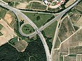 Wolnzach Autobahndreieck Holledau Aerial.jpg 979 × 735; 301 KB

.jpg)
.jpg)


.jpg)
