Category:Aerial photographs of Queens, New York City
Jump to navigation
Jump to search
Boroughs of New York City: Bronx · Brooklyn · Manhattan · Queens · Staten Island
Counties of New York City:
Counties of New York City:
Subcategories
This category has the following 5 subcategories, out of 5 total.
J
L
R
Media in category "Aerial photographs of Queens, New York City"
The following 99 files are in this category, out of 99 total.
-

-
 2010 New York City aerial.jpg 2,617 × 3,489; 1.84 MB
-
 08-JUL-2022 - UA5546 LGA-ORD (E175 - N209SY) (02).jpg 2,048 × 1,536; 1.1 MB
-
 26th MEU conducts humanitarian assistance survey of NYC 121103-M-ZC556-001.jpg 1,500 × 844; 838 KB
-
 26th MEU Hurricane Sandy Response (Image 60 of 60) (8164650485).jpg 1,280 × 720; 614 KB
-

-

-
-
 Admirando panorama - panoramio.jpg 1,280 × 960; 306 KB
-
 Aerial Photo of East River Tunnel Portals.jpg 4,032 × 3,024; 4.61 MB
-
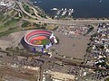
 Aerial Shot of Citi Field Opening Day April 13th 2009.jpg 4,752 × 3,168; 12.01 MB
-

-
 Aerial view of Aqueduct Race Track from the west 01 (9454225771).jpg 4,288 × 2,848; 6.11 MB
-
 Aerial view of Aqueduct Race Track from the west 01 - white balanced (9457023452).jpg 4,288 × 2,848; 8.58 MB
-
 Aerial view of Broad Channel station and surroundings, August 2019.JPG 5,184 × 3,888; 4.11 MB
-
 Aerial view of former The Raunt station location, August 2019.JPG 5,184 × 3,888; 2.99 MB
-
 Aerial view of Mt Judah and other cemeteries in Queens, NY 01 (9456983764).jpg 4,288 × 2,848; 6.64 MB
-

-
 Aerial view of New York City showing top of Chrysler Building and United Nations LCCN2011632592.tiff 6,087 × 4,789; 166.83 MB
-
 Aerial view of New York City showing top of Chrysler Building and United Nations LCCN2011632593.tiff 6,105 × 4,801; 167.74 MB
-
 Aerial view of North Channel Bridge and causeway, August 2019.JPG 4,831 × 3,220; 3.43 MB
-
 Aerial view of Silver Hole Marsh, July 2019.JPG 3,597 × 2,397; 1.33 MB
-
 Aerial view of South Channel Bridge, July 2019.JPG 4,946 × 3,297; 2.86 MB
-
 Aerial view of Subway Island, July 2019.JPG 4,336 × 2,892; 2.64 MB
-
 Aerial View of the Throgs Neck Bridge.jpg 1,024 × 562; 199 KB
-
 Aerial View of the Whitestone Bridge.jpg 568 × 212; 9 KB
-
 Aerial view Shea Stadium with Manhattan in background 1981.jpg 1,799 × 1,199; 475 KB
-
 Aqueduct Racetrack (35145767861).jpg 2,400 × 1,600; 2.8 MB
-
 Aqueduct Racetrack.jpg 4,121 × 2,855; 8.71 MB
-
 Belt Parkway Aerial (36080142034).jpg 2,400 × 1,600; 2.64 MB
-
 Calvary Cemetery (50425374527).jpg 4,032 × 3,024; 4.4 MB
-
 Cedar Grove Cemetery (8021084440).jpg 3,648 × 2,736; 4.9 MB
-
 Citi Field and Arthur Ashe Stadium.jpg 1,512 × 2,412; 1.57 MB
-
 Defense.gov photo essay 090525-M-8358P-166.jpg 4,498 × 2,888; 2.21 MB
-
 Floral Park, Queens (36106319043).jpg 2,400 × 1,600; 2.95 MB
-
 Flushing Line from above vc.jpg 4,592 × 3,448; 10.83 MB
-
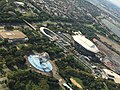
 Flushing Meadows–Corona Park, Queens-20170326-007 (33727867406).jpg 3,992 × 2,992; 8.77 MB
-
 Flushing, Queens 1 (35145736171).jpg 2,400 × 1,600; 2.32 MB
-
 Flushing, Queens 2 (35145736471).jpg 2,400 × 1,600; 2.39 MB
-
 Flushing, Queens 3 (35145736741).jpg 2,400 × 1,600; 2.32 MB
-
 Flushing, Queens, NY, USA - panoramio (1).jpg 1,598 × 899; 534 KB
-
 Flushing, Queens, NY, USA - panoramio (8).jpg 2,311 × 1,303; 636 KB
-
 Flushing, Queens, NY, USA - panoramio (9).jpg 2,639 × 1,486; 1.21 MB
-
 Flushing, Queens, NY, USA - panoramio.jpg 1,918 × 1,080; 596 KB
-

-
 Hell Gate and Triborough Bridges New York City Queens.jpg 1,128 × 741; 280 KB
-

-
 Howard Beach, Queens (35145768711).jpg 2,400 × 1,600; 2.48 MB
-
 I-678 Whitestone Expressway Aerial (34466212533).jpg 2,400 × 1,600; 2.68 MB
-
 Jackson Heights LGA Shea Stadium.jpg 1,024 × 768; 747 KB
-
 Jamaica (LIRR station) - panoramio (1).jpg 4,272 × 2,848; 3.47 MB
-
 Jamaica Bay aerial from NW 01 (9454438717).jpg 4,288 × 2,848; 5.62 MB
-
 Jamaica Bay aerial from NW 01 - white balanced (9457234768).jpg 4,288 × 2,848; 7.96 MB
-
 Jamaica Bay aerial from NW 02 (9454276843).jpg 4,288 × 2,848; 5.14 MB
-
 Jamaica Bay aerial from NW 02 - white balanced (9457072086).jpg 4,288 × 2,848; 7.46 MB
-
 LaGuardia Airport and environs aerial from the south 01 - white balanced (9456947362).jpg 4,288 × 2,848; 8.95 MB
-
 Laurelton Zoom (36914251515).jpg 1,600 × 2,400; 2.31 MB
-
 Laurelton, Queens (36080141434).jpg 2,400 × 1,600; 2.49 MB
-
 LIRR Hillside Maintenance Complex in Queens.jpg 5,472 × 3,648; 18.83 MB
-
 Long Island Sound.jpg 3,504 × 2,336; 6.9 MB
-
 Montefiore Cemetery aerial 2021.jpg 6,240 × 4,160; 11.04 MB
-
 Newtown Creek (Queens) aerial 01 (9457033476).jpg 4,288 × 2,848; 6.16 MB
-
 Newtown Creek (Queens) aerial 02 (9454373737).jpg 4,288 × 2,848; 6.15 MB
-
 Newtown Creek (Queens) aerial 03 (9454384501).jpg 4,288 × 2,848; 6.28 MB
-
 Newtown Creek (Queens) aerial 04 (9454395413).jpg 4,288 × 2,848; 5.42 MB
-
 Newtown Creek (Queens) aerial 05 (9457189092).jpg 4,288 × 2,848; 6.38 MB
-
 Newtown Creek (Queens) aerial 06 (9457199296).jpg 4,288 × 2,848; 6.21 MB
-
 Newtown Creek (Queens) aerial 07 (9454428733).jpg 4,288 × 2,848; 6.37 MB
-
 North Shore of Long Island 2021.jpg 6,240 × 4,160; 8.84 MB
-
 North Shore Towers aerial 2021.jpg 6,240 × 4,160; 7.97 MB
-
 NY Long Island Sands Point IMG 1947.JPG 4,470 × 2,369; 5.83 MB
-
 NYC City under Ice.jpg 1,936 × 2,592; 1.81 MB
-
 NYC- Long Island and Manhattan (5068609111).jpg 2,640 × 1,980; 1.23 MB
-
 Queens - August 2017 (36904031946).jpg 4,032 × 3,024; 2.81 MB
-
 Queens aerial 2021.jpg 6,240 × 4,160; 8.69 MB
-
 Queens cemeteries.jpg 2,448 × 3,264; 3.2 MB
-
 Queens-20170326-005-5 (33768593205).jpg 3,719 × 2,092; 4.45 MB
-
 Queensboro Bridge etc aerial from Queens 01 (9453980415).jpg 4,288 × 2,848; 5.29 MB
-
 Queensboro Bridge etc aerial from Queens 01 - equalized (9453999119).jpg 4,288 × 2,848; 9.95 MB
-
 Queensboro Bridge etc aerial from Queens 02 (9456789668).jpg 4,288 × 2,848; 5.02 MB
-
 Queensboro Bridge etc aerial from Queens 02 - equalized (9456810540).jpg 4,288 × 2,848; 10.69 MB
-
 Secretary Blinken Arrives in New York City - 53093460121.jpg 4,000 × 2,668; 816 KB
-
 Shadow of airplane crosses the New York State Pavilion at Flushing Meadows in 1981.jpg 1,799 × 1,199; 467 KB
-
 Sheastadiumfromtheair.jpg 800 × 600; 255 KB
-
 Southern Queens 2022.jpg 6,240 × 4,160; 13.61 MB
-
 Southwest Long Island aerial view.jpg 3,000 × 2,000; 3.83 MB
-

-
-
 Throgs Neck Bridge aerial 2003.jpg 1,024 × 557; 415 KB
-
 Throgs Neck Bridge from SW 01 (9453860339).jpg 4,288 × 2,848; 4.85 MB
-
 Throgs Neck Bridge from SW 01 - equalized (9453879185).jpg 4,288 × 2,848; 8.9 MB
-
 Throgs Neck Bridge from the air.jpg 921 × 851; 247 KB
-
 Triborough Bridge and Hell Gate New York City Queens-edit.jpg 600 × 381; 257 KB
-
 US OPEN 2019 (48667511866).jpg 3,934 × 2,430; 2.06 MB
-
 Valley Stream NY and parkways.jpg 2,579 × 1,069; 1.08 MB
-

-
 View of New York from the Air (October 2023) 09.jpg 6,000 × 4,000; 12.33 MB
-
 View of New York from the Air (October 2023) 14.jpg 6,000 × 4,000; 10.76 MB
-
 Whitestone and Throgs Neck Bridges (4430040614).jpg 3,504 × 2,336; 6.94 MB

_(02).jpg)

_(8164650485).jpg)
_(16458228567).jpg)
_(16639606536).jpg)
.jpg)


.jpg)
.jpg)


.jpg)
.jpg)


.jpg)

.jpg)
.jpg)
.jpg)


.jpg)

.jpg)
.jpg)
.jpg)
.jpg)
.jpg)
.jpg)
.jpg)


.jpg)
.jpg)

_-_panoramio_(1).jpg)
.jpg)
.jpg)
.jpg)
.jpg)
.jpg)
.jpg)
.jpg)


_aerial_01_(9457033476).jpg)
_aerial_02_(9454373737).jpg)
_aerial_03_(9454384501).jpg)
_aerial_04_(9454395413).jpg)
_aerial_05_(9457189092).jpg)
_aerial_06_(9457199296).jpg)
_aerial_07_(9454428733).jpg)


.jpg)
.jpg)


.jpg)
.jpg)
.jpg)
.jpg)
.jpg)


.jpg)
.jpg)


.jpg)


_09.jpg)
_14.jpg)
.jpg)