Category:Adare Franciscan Friary
Jump to navigation
Jump to search
| Object location | | View all coordinates using: OpenStreetMap |
|---|

|
This object is indexed in the Archaeological Survey of Ireland under SMR No. LI021-032007-
Geographic information system of the National Monuments Service: Historic Environment Viewer – Database record. |
monastery ruins in Adare, County Limerick, Ireland  | |||||
| Upload media | |||||
| Instance of |
| ||||
|---|---|---|---|---|---|
| Location | Adare, County Limerick, Munster, Ireland | ||||
| Inception |
| ||||
 | |||||
Media in category "Adare Franciscan Friary"
The following 7 files are in this category, out of 7 total.
-
 Abbey, Adare, Limerick (5260848004).jpg 600 × 390; 68 KB
-
 ADARE ABBEY.jpg 2,262 × 1,784; 721 KB
-
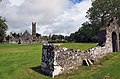 Adare Friary (2) - geograph.org.uk - 3036089.jpg 640 × 422; 338 KB
-
 Adare Friary - geograph.org.uk - 3036086.jpg 640 × 429; 287 KB
-
 AdareFranciscanFriary.JPG 4,608 × 3,440; 7.75 MB
-
 AdareFranciscanFriaryInterior.JPG 3,440 × 4,608; 7.77 MB
-
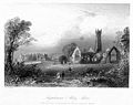
 Journal of the Royal Society of Antiquaries of Ireland (1916) (14593982949).jpg 2,278 × 3,776; 1.62 MB
.jpg)

_-_geograph.org.uk_-_3036089.jpg)


_(14593982949).jpg)