Category:Achnahanat
Jump to navigation
Jump to search
human settlement in Highland, Scotland, UK  | |||||
| Upload media | |||||
| Instance of | |||||
|---|---|---|---|---|---|
| Location |
| ||||
 | |||||
English: Achnahanat is a crofting settlement located near Ardgay, in Sutherland, Scotland, within the Scottish council area of Highland.
Nederlands: Achnahanat is een nederzetting in de buurt van Ardgay in Sutherland in de Schotse Hooglanden.
Media in category "Achnahanat"
The following 33 files are in this category, out of 33 total.
-
 Achnahanat - geograph.org.uk - 1529080.jpg 640 × 480; 72 KB
-
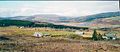 Achnahanat.jpg 601 × 259; 36 KB
-
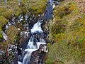 Aullt a Ghugheran - geograph.org.uk - 307638.jpg 640 × 480; 188 KB
-
 Croft House - geograph.org.uk - 55953.jpg 640 × 480; 115 KB
-
 Loch Dubh - geograph.org.uk - 48387.jpg 640 × 480; 115 KB
-
 The Old School House - geograph.org.uk - 55956.jpg 640 × 480; 122 KB
-
 Wester Rynechkra - geograph.org.uk - 729740.jpg 640 × 480; 89 KB
-
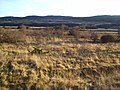 A Countryside View - geograph.org.uk - 115292.jpg 640 × 480; 103 KB
-
 A Crofting Community - geograph.org.uk - 55968.jpg 640 × 480; 115 KB
-
 A Crofting Community - geograph.org.uk - 55973.jpg 640 × 480; 131 KB
-
 Achintoul near Altass - geograph.org.uk - 238537.jpg 640 × 480; 351 KB
-
 Achnagart Farm - geograph.org.uk - 641461.jpg 480 × 640; 55 KB
-
 Allt Clais nam Foid Burn - geograph.org.uk - 56039.jpg 640 × 480; 154 KB
-
 Allt Clais nam Foid Burn - geograph.org.uk - 56042.jpg 640 × 480; 168 KB
-
 Allt Clais nam Foid Burn - geograph.org.uk - 56045.jpg 640 × 480; 183 KB
-
 Altass More - geograph.org.uk - 238515.jpg 640 × 480; 313 KB
-
 Back entrance into Middle Hill Woods - geograph.org.uk - 609900.jpg 640 × 426; 61 KB
-
 Between Tullich and Middle Hill Woods - geograph.org.uk - 609882.jpg 640 × 426; 40 KB
-
 Bits and pieces around Achnagart - geograph.org.uk - 641458.jpg 640 × 480; 47 KB
-
 Braemore Woods - geograph.org.uk - 238437.jpg 640 × 480; 329 KB
-
 Buildings by Woodburn - geograph.org.uk - 609801.jpg 640 × 426; 60 KB
-
 Cedar lodge - geograph.org.uk - 609831.jpg 640 × 426; 55 KB
-
 Farm by Tullich woods - geograph.org.uk - 609877.jpg 640 × 426; 43 KB
-
-
 Forestry Road - geograph.org.uk - 55939.jpg 640 × 480; 163 KB
-
 Forestry Road - geograph.org.uk - 55964.jpg 640 × 480; 135 KB
-
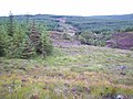
 Hillside above plantation - geograph.org.uk - 721030.jpg 640 × 427; 33 KB
-
 Linsidemore Wood - geograph.org.uk - 307626.jpg 640 × 480; 113 KB
-
 Linsidemore Wood - geograph.org.uk - 307635.jpg 640 × 480; 168 KB
-
 Linsidemore Wood Forest Road - geograph.org.uk - 307621.jpg 640 × 480; 107 KB
-
 Linsidemore Wood, Aullt a Ghugheran - geograph.org.uk - 307630.jpg 640 × 480; 145 KB
-
 Loch an Daimh Ldhir - geograph.org.uk - 48391.jpg 640 × 480; 124 KB
-
 Sheep pen remains - geograph.org.uk - 609862.jpg 640 × 426; 61 KB


