Category:A131 road (England)
Jump to navigation
Jump to search

road in England   | |||||
| Upload media | |||||
| Instance of | |||||
|---|---|---|---|---|---|
| Location |
| ||||
| Transport network |
| ||||
| Has part(s) |
| ||||
| Length |
| ||||
| |||||
Subcategories
This category has the following 2 subcategories, out of 2 total.
H
- High Garrett (1 F)
Media in category "A131 road (England)"
The following 12 files are in this category, out of 12 total.
-
 A131 Melford Rd - geograph.org.uk - 674474.jpg 640 × 480; 76 KB
-
 A131 Newton Road - geograph.org.uk - 801165.jpg 640 × 480; 87 KB
-
 A131 Newton Road, looking east - geograph.org.uk - 801170.jpg 640 × 480; 83 KB
-
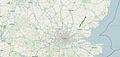 A131 road map.jpg 1,836 × 866; 166 KB
-
 A131, Bridge Street - geograph.org.uk - 941055.jpg 640 × 480; 80 KB
-
 A131, Gainsborough Road - geograph.org.uk - 624319.jpg 640 × 480; 67 KB
-
 A131, Stour Street - geograph.org.uk - 1037845.jpg 640 × 480; 107 KB
-
 A131Melford Road - geograph.org.uk - 674477.jpg 640 × 480; 76 KB
-
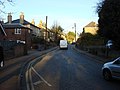
 Bridge Street, Halstead - geograph.org.uk - 1603983.jpg 640 × 461; 72 KB
-
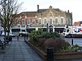
 Long Gardens - geograph.org.uk - 1463742.jpg 640 × 396; 69 KB
-
-
 UK road A131.PNG 568 × 184; 6 KB


