Category:6 Chopin Street in Lublin
Jump to navigation
Jump to search
| Object location | | View all coordinates using: OpenStreetMap |
|---|
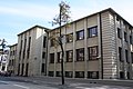
Polski: Lublin, ul. Chopina 6 - zespół d. Banku Rolnego, 1934-1936:
- Bank Rolny, 1934-1936 (ID 606004)
- ogrodzenie, 1934-1936 (ID 606005)
Media in category "6 Chopin Street in Lublin"
The following 11 files are in this category, out of 11 total.
-
 Lublin 348.jpg 2,816 × 1,880; 1.79 MB
-
 Lublin 352.jpg 2,816 × 1,880; 1.91 MB
-
 Lublin 353.jpg 2,816 × 1,880; 2.11 MB
-
 Lublin 358.jpg 2,816 × 1,880; 1.76 MB
-
 Lublin 368.jpg 1,880 × 2,816; 1.73 MB
-
 Lublin Chopina 6 bank night.jpg 4,764 × 3,075; 9.18 MB
-
 Lublin, ul.Chopina 6, obecnie budynek NBP.JPG 3,648 × 2,736; 5.49 MB
-
 Lublin, ul.Chopina 7, obecnie budynek NBP.JPG 3,648 × 2,736; 5.54 MB
-
 Lublin, ul.Chopina 8, obecnie budynek NBP.JPG 3,648 × 2,736; 4.58 MB
-
 PL Lublin Chopina6 NBP.jpg 2,426 × 1,661; 2.15 MB
-
 PL Lublin Chopina6.jpg 2,534 × 1,521; 2.41 MB


