Category:55, Nowy Świat Street
Jump to navigation
Jump to search
| Object location | | View all coordinates using: OpenStreetMap |
|---|
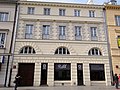
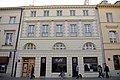
Polski: Jedna z kamienic Mikulskiego w Warszawie, Nowy Świat 55
 | |||||
| Upload media | |||||
| Instance of | |||||
|---|---|---|---|---|---|
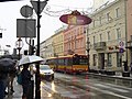
| Location | Śródmieście, Warsaw, Masovian Voivodeship, Poland | ||||
| Street address |
| ||||
| Heritage designation |
| ||||
| Inception |
| ||||
| Significant event |
| ||||
 | |||||
Media in category "55, Nowy Świat Street"
The following 5 files are in this category, out of 5 total.
-
 55, Nowy Świat Street - 01.jpg 3,648 × 2,736; 1.83 MB
-
 Kamienica przy ul. Nowy Świat 55 w Warszawie 2020.jpg 5,139 × 3,952; 10.58 MB
-
 Nowy świat 53 55.jpg 843 × 720; 428 KB
-
 Nowy Świat 55-61 Warszawa.jpg 4,000 × 3,000; 2.4 MB
-
 NowySwiat 55.jpg 4,672 × 3,104; 8.35 MB


