Category:33 & 35 Hope Street, Liverpool
Jump to navigation
Jump to search
| Object location | | View all coordinates using: OpenStreetMap |
|---|
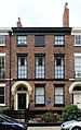
house in Liverpool, Merseyside, UK  | |||||
| Upload media | |||||
| Instance of | |||||
|---|---|---|---|---|---|
| Location | Liverpool, Merseyside, North West England, England | ||||
| Heritage designation |
| ||||
 | |||||
Early 19th century terraced houses on Hope Street, Grade II listed along with 2 Blackburne Place
Media in category "33 & 35 Hope Street, Liverpool"
The following 7 files are in this category, out of 7 total.
-
 33 & 35 Hope Street, Liverpool 1.jpg 4,456 × 3,056; 8 MB
-
 33 & 35 Hope Street, Liverpool-geograph-3080105.jpg 457 × 386; 171 KB
-
 33 Hope Street, Liverpool.jpg 3,066 × 4,882; 7.77 MB
-
 33-47 Hope Street, Liverpool (geograph 5028419).jpg 640 × 506; 178 KB
-
 35 Hope Street, Liverpool.jpg 3,144 × 4,840; 7.87 MB
-
 Plaque on 33 Hope Street.jpg 5,152 × 3,864; 7.92 MB
-
 Plaque on 35 Hope Street.jpg 3,433 × 4,577; 11.92 MB


.jpg)


