Category:23 Świętego Marka street in Kraków
Jump to navigation
Jump to search
| Object location | | View all coordinates using: OpenStreetMap |
|---|
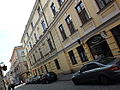
house in Kraków, Poland  | |||||
| Upload media | |||||
| Instance of | |||||
|---|---|---|---|---|---|
| Location | Kraków, Lesser Poland Voivodeship, Poland | ||||
| Street address |
| ||||
| Heritage designation |
| ||||
| Inception |
| ||||
 | |||||
| Address |
|
| Address |
|
Media in category "23 Świętego Marka street in Kraków"
The following 3 files are in this category, out of 3 total.
-
 Kraków, ul. Św. Marka 23 fot. 001.jpg 4,000 × 3,000; 3.87 MB
-
 Kraków, ul. Św. Marka 23 fot. 002.jpg 4,000 × 3,000; 3.98 MB
-
 Kraków, ul. Św. Marka 23 fot. 003.jpg 3,000 × 4,000; 3.77 MB

