Category:20 Królika Street in Tarnowskie Góry
Jump to navigation
Jump to search
| Object location | | View all coordinates using: OpenStreetMap |
|---|
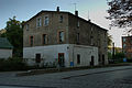
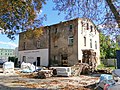
Polski: Tarnowskie Góry, ul. Teofila Królika 20 - budynek mieszkalny
house in Tarnowskie Góry, Silesian Voivodeship, Poland  | |||||
| Upload media | |||||
| Instance of | |||||
|---|---|---|---|---|---|
| Location | Tarnowskie Góry, Tarnowskie Góry county, Silesian Voivodeship, Poland | ||||
| Street address |
| ||||
| Heritage designation |
| ||||
| Inception |
| ||||
 | |||||
Media in category "20 Królika Street in Tarnowskie Góry"
The following 6 files are in this category, out of 6 total.
-
 Budynek mieszkalny przy ul. T. Królika 20 w Tarnowskich Górach.jpg 3,056 × 4,592; 4.16 MB
-
 Tarnowskie Góry Królika 20.jpg 4,600 × 3,072; 3.89 MB
-
 Tarnowskie Góry, dom, ul. Królika 20 01.jpg 4,096 × 3,072; 9.16 MB
-
 Tarnowskie Góry, dom, ul. Królika 20 02.jpg 3,906 × 3,087; 8.46 MB
-
 Tarnowskie Góry, ul. Królika 20.jpg 4,017 × 3,013; 4.89 MB
-
 Tarnowskie Góry, ul. T. Królika 20.jpg 4,116 × 3,088; 3.47 MB


