Category:20 - 26 Oxford Street, Liverpool
Jump to navigation
Jump to search
| Object location | | View all coordinates using: OpenStreetMap |
|---|
building in Liverpool, Merseyside, UK  | |||||
| Upload media | |||||
| Instance of | |||||
|---|---|---|---|---|---|
| Location | Liverpool, Merseyside, North West England, England | ||||
| Heritage designation |
| ||||
 | |||||
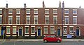
1820s terrace of four brick houses, Grade II listed.
Subcategories
This category has only the following subcategory.
2
Media in category "20 - 26 Oxford Street, Liverpool"
The following 4 files are in this category, out of 4 total.
-
 20 - 26 Oxford Street, Liverpool.jpg 7,132 × 3,866; 15.28 MB
-
 20 Oxford Street, Liverpool.jpg 2,680 × 4,592; 5.41 MB
-
 22 Oxford Street, Liverpool.jpg 2,318 × 4,328; 4.11 MB
-
 24 Oxford Street, Liverpool.jpg 2,280 × 4,320; 4.45 MB


