Category:2018 maps of California
Jump to navigation
Jump to search
States of the United States: California · Colorado · Iowa · Louisiana · New York · Pennsylvania · Utah · Virginia – Washington, D.C.
| ← 2010 2011 2012 2013 2014 2015 2016 2017 2018 2019 → |
Media in category "2018 maps of California"
The following 6 files are in this category, out of 6 total.
-
 AmphibiousTrainingBaseMorroBay.jpg 614 × 424; 32 KB
-
 BART system map effective May 2018.png 8,400 × 7,000; 915 KB
-
 BART web map effective May 2018.gif 500 × 500; 48 KB
-
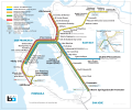
 BART web map effective September 2018.png 1,000 × 803; 59 KB
-
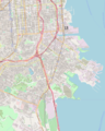 Location map San Francisco Bayview-Hunters Point.png 1,600 × 1,999; 3 MB
-
 San Francisco.svg 512 × 458; 253 KB


