Category:2017 maps of France
Jump to navigation
Jump to search
Countries of Europe: Albania · Belarus · Bulgaria · France‡ · Germany · Greece · Italy · Lithuania · Russia‡ · Spain‡ · Switzerland · Turkey‡ · Ukraine
‡: partly located in Europe
‡: partly located in Europe
Subcategories
This category has only the following subcategory.
L
Media in category "2017 maps of France"
The following 10 files are in this category, out of 10 total.
-
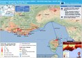 20170726 DailyMap France ForestFires.pdf 1,754 × 1,239; 952 KB
-
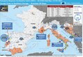 20170727 Forest Fires in Southern Europe.pdf 1,625 × 1,125; 988 KB
-
 Carte 2017 .jpg 4,134 × 2,836; 4.19 MB
-
 Fréquence de l'occurrence du nom de famille.png 2,500 × 2,500; 334 KB
-
 Généralité-de-Montauban 1635-1715.jpg 1,920 × 2,062; 478 KB
-
 Généralité-de-Montauban 1716-1790.jpg 1,920 × 1,336; 265 KB
-
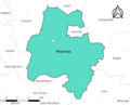
 Locator map of Departement Loir-et-Cher.png 2,500 × 2,585; 1.41 MB
-
 Ploermel-2017.png 3,057 × 2,480; 489 KB
-
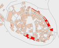 Pérouges MH Remparts.svg 650 × 525; 109 KB
-
 Réseau autoroutier français - 2017.svg 1,195 × 1,179; 369 KB


