Category:2017 aerial photographs of Namibia
Jump to navigation
Jump to search
Media in category "2017 aerial photographs of Namibia"
The following 187 files are in this category, out of 187 total.
-
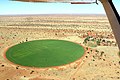
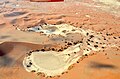
 Aerial view of Fairy circles, Namibia (2017).jpg 4,928 × 3,264; 9.91 MB
-
 Aerial view of Farm Simplon, Namibia (2017).jpg 4,286 × 2,847; 7.06 MB
-
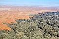
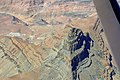
 Aerial view of Fish River Canyon (2017).jpg 4,928 × 3,264; 7.22 MB
-
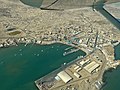
 Aerial view of Lüderitz (2017).jpg 4,928 × 3,264; 7.69 MB
-
 Aerial view of old lime kiln, Simplon Namibia (2017).jpg 4,526 × 3,033; 7.12 MB
-
 Aerial view of Swakopmund Lighthouse, Namibia.jpg 4,452 × 3,061; 6.82 MB
-
 Agglomeration um den Goreangab Damm.jpg 5,472 × 3,648; 9.99 MB
-
 Airfield Aus (Namibia).jpg 4,928 × 3,264; 7.88 MB
-
 Aminuis bird eye view.jpg 5,472 × 3,648; 8.3 MB
-
 Aranos bird eye view.jpg 5,472 × 3,648; 10.3 MB
-
 Aranos High School.jpg 5,472 × 3,648; 7.83 MB
-
 Aroams Oos in Tswanaland, Namibia (2017).jpg 4,519 × 2,941; 4.88 MB
-
 Auob at Gochas.jpg 5,472 × 3,648; 9.11 MB
-
 Bahn Sand.jpg 4,928 × 3,264; 3.84 MB
-
 Bahnhof Gobabis Luftaufnahme (2017).jpg 5,472 × 3,648; 7.8 MB
-
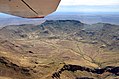
 Billstein mountain, Namibia (2017).jpg 4,563 × 3,075; 7.23 MB
-
 Blick in die Berge der Doppelkuppe, Namibia (2017).jpg 4,928 × 3,264; 7.05 MB
-
 Brukkaros aerial view (2017).jpg 5,472 × 3,648; 13.43 MB
-
 Brukkaros Bird's Eye View.jpg 2,024 × 1,349; 2.8 MB
-
 Brukkaros Mountain, Namibia (2017).jpg 4,928 × 3,264; 7.73 MB
-
 Canyon Village in Namibia (2017).jpg 4,529 × 2,900; 8.6 MB
-
 Canyon Village, Gondwana, Namibia (2017).jpg 4,386 × 2,803; 7.75 MB
-
 D1985, Verbindungsstraße zwischen C28 und D1982 in Namibia.jpg 4,532 × 2,993; 6.11 MB
-
 Dead Vlei, Namibia (2017).jpg 4,928 × 3,264; 7.69 MB
-
 Deadvlei Vogelperspektive.jpg 4,928 × 3,264; 6.78 MB
-
 Der Swakop NE Langer Heinrich, Namibia (2017).jpg 4,928 × 3,264; 7.3 MB
-
 Desert Homestead Lodge (2017).jpg 4,618 × 3,018; 7.38 MB
-
 Desert Homestead, Namibia (2017).jpg 4,469 × 3,035; 5.14 MB
-
 Diamantensperrgebiet.jpg 5,472 × 3,648; 9.62 MB
-
 District road D1237, Rehoboth (Namibia).jpg 4,928 × 3,264; 8.77 MB
-
 Distriktstraße D1001 bei Farm Gunsteling, Namibia (2017).jpg 4,928 × 3,264; 6.76 MB
-
 Distriktstraße D1984 und Eisenbahnlinie bei Walvis Bay (2017).jpg 4,928 × 3,264; 5.43 MB
-
 Distriktstraße D3819, Namibia (2017).jpg 4,928 × 3,264; 6.47 MB
-
 Distriktstraße D707 bei Farm Kanaan (Namibia).jpg 4,928 × 3,264; 6.87 MB
-
 Distriktstraße D707 bei Namtib (Namibia).jpg 4,928 × 3,264; 5.97 MB
-
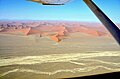
 Dune 45, Sossusvlei (2017).jpg 4,928 × 3,264; 5.79 MB
-
 Dunes and Tsauchab, Sossusvlei (2017).jpg 4,928 × 3,264; 6.83 MB
-
 Dunes at Tsauchab valley, Namibia (2017).jpg 4,928 × 3,264; 9.66 MB
-
 Dunes of Sossusvlei region, Namibia (2017).jpg 4,928 × 3,264; 10.01 MB
-
 Dünen (Namib).jpg 5,760 × 3,840; 6.85 MB
-
 Dünen bei Sossusvlei, Namibia (2017).jpg 4,928 × 3,264; 7.97 MB
-
 Ejuva I and II bird eye view.jpg 5,472 × 3,648; 9.45 MB
-
 Elegant Desert Lodge, Namibia (2017).jpg 4,928 × 3,264; 7.21 MB
-
 Extended Runway Walvis Bay Airport (2017).jpg 4,928 × 3,264; 5.59 MB
-
 Farm Edelweiss in Namibia Bird Eye View.jpg 5,472 × 3,648; 7.12 MB
-
 Farm Gunsteling, Namibia (2017).jpg 4,928 × 3,264; 5.28 MB
-
 Farm in Namibia (2017).jpg 3,937 × 2,518; 3.86 MB
-
 Farm Langverwacht, Namibia (2017).jpg 4,928 × 3,264; 5.75 MB
-
 Farm Makam, Namibia (2017).jpg 4,306 × 2,902; 5.39 MB
-
 Farm Nuiba in Namibia (2017).jpg 4,563 × 2,994; 4.62 MB
-
 Farm within Kalahari Desert (Namibia).jpg 4,536 × 2,961; 6.03 MB
-
 Farm within Kalahari Desert, Namibia.jpg 4,928 × 3,264; 5.75 MB
-
 Fischfluss-Canyon 2017.jpg 3,264 × 2,448; 5.68 MB
-
 Fish River Canyon aerial view, Namibia (2017).jpg 4,691 × 3,082; 8.64 MB
-
 Fish River Canyon, Namibia.jpg 4,928 × 3,264; 8.66 MB
-
 Flughafen Walfish Bay Luftaufnahme.jpg 4,928 × 3,264; 4.08 MB
-
 Flugplatz Swakopmund Vogelperspektive.jpg 4,928 × 3,264; 6.52 MB
-
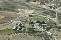
 Gobabis Private Hospital.jpg 5,472 × 3,648; 7.61 MB
-
 Gochas aerial view.jpg 5,472 × 3,648; 8.69 MB
-
 Gochas bird eye view.jpg 4,928 × 3,264; 5.03 MB
-
 Gochas Nord.jpg 5,472 × 3,648; 9.06 MB
-
 Goreangab Dam.jpg 5,472 × 3,648; 9.03 MB
-
 Goreangab Damm.jpg 5,472 × 3,648; 7.37 MB
-
 Gravel road along Fish River Canyon, Namibia (2017).jpg 4,739 × 3,073; 6.67 MB
-
 H.E.S.S. Vogelperspektive 2017.jpg 4,928 × 3,264; 8.09 MB
-
 Haltepunkt Haalenberg an der Bahnstrecke Lüderitz-Seeheim (2017).jpg 4,604 × 2,967; 7.92 MB
-
 Hauptstraße C13 bei Aus, Namibia (2017).jpg 4,928 × 3,264; 5.77 MB
-
 Hauptstraße C13 bei Rosh Pinah, Namibia (2017).jpg 4,928 × 3,264; 5.9 MB
-
 Hauptstraße C19 bei Sesriem, Namibia (2017).jpg 4,928 × 3,264; 6.33 MB
-
 Hauptstraße C22, Namibia (2017).jpg 4,928 × 3,264; 5.83 MB
-
 Hauptstraße C27, Namibia.jpg 4,928 × 3,264; 5.62 MB
-
 Hebron Falte, Namibia (2017).jpg 4,928 × 3,264; 7.95 MB
-
 Hebronfalte in Namibia (2017).jpg 4,928 × 3,264; 6.38 MB
-
 Heldenacker Namibia Vogelperspektive. 2017.jpg 4,602 × 2,995; 7.64 MB
-
 Hobas Airfield, Namibia (2017).jpg 3,690 × 2,266; 4.76 MB
-
 Husab Mine and Klan mountains, Namibia (2017).jpg 4,464 × 2,867; 4.46 MB
-
 Husab Mountains, Namibia (2017).jpg 4,630 × 2,980; 4.67 MB
-
 Inachabkuppe in Namibia (2017).jpg 4,321 × 2,763; 4.64 MB
-
 Inachabkuppe Radar reflector, Namibia (2017).jpg 4,691 × 3,056; 4.97 MB
-
 Inachabkuppe, Karas, Namibia.jpg 4,551 × 2,935; 5.38 MB
-
 Inachabkuppe, Namibia (2017).jpg 4,691 × 3,056; 8.04 MB
-
 Inachabkuppe, Southern Namibia (2017).jpg 4,262 × 2,849; 9.06 MB
-
 Jakalswater Bahnstation.jpg 4,928 × 3,264; 5.86 MB
-
 Jakalswater, alte Bahnstation (Namibia).jpg 4,928 × 3,264; 7.12 MB
-
 Jakalswater, alte Bahnstation in Namibia.jpg 4,928 × 3,264; 7.59 MB
-
 Kalahari Lehmpfanne.jpg 4,928 × 3,264; 4.43 MB
-
 Kanaan Desert Retreat, Namibia (2017).jpg 4,215 × 2,745; 4.7 MB
-
 Karibib aerial view.jpg 5,472 × 3,648; 8.94 MB
-
 Keetmanshoop bird eye view.jpg 4,928 × 3,264; 7.15 MB
-
 Keetmanshoop Railway Station bird eye view.jpg 4,928 × 3,264; 7.22 MB
-
 Klein Aus Vista, Aerial View (2017).jpg 4,895 × 3,074; 7.45 MB
-
 Kolmanskop near Lüderitz, Namibia (2017).jpg 4,652 × 3,052; 6.86 MB
-
 Krater des Brukkaros, Namibia (2017).jpg 4,928 × 3,264; 5.35 MB
-
 Kreisförmige Luzernefelder Kalahari.jpg 5,472 × 3,648; 10.85 MB
-
 Kreuzung der Hauptstraßen C18 und C15 bei Gochas, Namibia (2017).jpg 4,928 × 3,264; 7.05 MB
-
 Kuiseb bird eye view.jpg 5,472 × 3,648; 9.87 MB
-
 Lake Oanob Bird´s eye view.jpg 4,928 × 3,264; 5.91 MB
-
 Landscape west of district road D459, Karas, Namibia (2017).jpg 4,693 × 2,956; 7.55 MB
-
 Langer Heinrich Namibia.jpg 4,928 × 3,264; 6.04 MB
-
 Linker Nebenfluss des Swakop in Namibia (2017).jpg 4,928 × 3,264; 7.19 MB
-
 Luderitz bird's eye view.jpg 2,024 × 1,518; 2.53 MB
-
 Luftaufnahme Sossusvlei (2017).jpg 4,928 × 3,264; 6.93 MB
-
 Luzerne Kalahari.jpg 5,472 × 3,648; 5.7 MB
-
 Lüderitz Robert Harbour and Islands, Namibia (2017).jpg 4,679 × 3,066; 6.66 MB
-
 Mariental bird eye view 2.jpg 5,472 × 3,648; 8.02 MB
-
 Marmor Karibib.jpg 5,472 × 3,648; 9.42 MB
-
 Mole Swakopmund, Namibia.jpg 4,632 × 2,954; 6 MB
-
 Mole, Jetty and Lighthouse Swakopmund, Namibia.jpg 4,384 × 2,951; 6.93 MB
-
 Mphe Thuto Primary School bird eye view.jpg 5,472 × 3,648; 7.37 MB
-
 Muendung des Swakop.jpg 4,928 × 3,264; 6.4 MB
-
 Mukurob gefallen.jpg 5,472 × 3,648; 8.89 MB
-
 MukurobBirdView.jpg 4,928 × 3,264; 4.72 MB
-
 Namib High School, Swakopmund.jpg 4,928 × 3,264; 7.18 MB
-
 Namib, nördlich von Tsondab.jpg 4,928 × 3,264; 8.88 MB
-
 Namibia Sperrgebiet Vogelperspektive.jpg 5,472 × 3,648; 7.61 MB
-
 Namibia Tony Rust race track bird's eye view.jpg 2,024 × 1,349; 3.72 MB
-
 Namibküste-2.jpg 5,419 × 3,613; 1.45 MB
-
 Namibküste.jpg 5,333 × 3,555; 16.72 MB
-
 Nationalstraße B4 bei Aus, Namibia (2017).jpg 4,928 × 3,264; 5.52 MB
-
 Nationalstraße B4 bei Lüderitz (2017).jpg 4,441 × 2,842; 5.09 MB
-
 Nationalstraße B4 nach Lüderitz, Namibia (2017).jpg 4,928 × 3,264; 8.2 MB
-
 NauteDamBirdView.jpg 5,472 × 3,648; 8.43 MB
-
 Neckartaldamm Oktober 2017.jpg 5,472 × 3,648; 9.68 MB
-
 Nonidas Vogelperspektive.jpg 4,466 × 2,887; 4.49 MB
-
 Nosob River bird eye view.jpg 5,472 × 3,648; 8.96 MB
-
 Nossob und Nebenstraße M39, Namibia (2017).jpg 4,928 × 3,264; 5.46 MB
-
 Nubibberge (2017).jpg 4,928 × 3,264; 5.41 MB
-
 Otavi 1945.jpg 5,472 × 3,648; 8.94 MB
-
 Platz am Meer (Shopping Mall Swakopmund), aerial view 2017.jpg 4,928 × 3,264; 6.97 MB
-
 Prinzessin Rupprecht Heim Vogelperspektive 2.jpg 4,928 × 3,264; 5.39 MB
-
 Prinzessin Rupprecht Heim Vogelperspektive.jpg 4,928 × 3,264; 5.31 MB
-
 Rehoboth Bird´s-eye view.jpg 4,928 × 3,264; 6.02 MB
-
 Robert Harbour, Redford Bay and Isles of Lüderitz (Namibia).jpg 4,928 × 3,264; 7.37 MB
-
 Roter Kamm Bird's Eye View.jpg 4,928 × 3,264; 5.26 MB
-
 Ruinen aus der Schutztruppen-Zeit Dicker Wilhelm.jpg 4,206 × 2,823; 12.03 MB
-
 Runway Keetmanshoop.jpg 4,928 × 3,264; 4.01 MB
-
 Rössingberge Vogelperspektive.jpg 4,821 × 3,033; 6.88 MB
-
 Salt evaporation ponds, Swakopmund.jpg 4,928 × 3,264; 4.44 MB
-
 Sand dune in the Kalahari Desert (Namibia).jpg 4,435 × 3,023; 5.85 MB
-
 Sandsturm in der Namib (2017).jpg 4,928 × 3,264; 6.41 MB
-
 Sandwich Harbour (Luftaufnahme).jpg 3,212 × 2,318; 1.59 MB
-
 Seebrücke Swakopmund, Namibia.jpg 4,928 × 3,264; 7.27 MB
-
 Shopping Mall (Platz am Meer) Swakopmund, aerial view 2017.jpg 4,928 × 3,264; 8.32 MB
-
 Skorpion Zink Mine.jpg 5,472 × 3,648; 6.5 MB
-
 Solar Power Plant and High Voltage Plant in Keetmanshoop.jpg 5,472 × 3,648; 8.09 MB
-
 Solar Power Plant Karibib.jpg 5,472 × 3,648; 8.08 MB
-
 Solar Power Plant Keetmanshoop.jpg 5,472 × 3,648; 9.68 MB
-
 Solar Power Plant Rosh Pinah.jpg 5,472 × 3,648; 8.95 MB
-
 Solitaire.jpg 5,472 × 3,648; 8.52 MB
-
 Sossusvlei aus der Vogelperspektive.jpg 4,928 × 3,264; 5.8 MB
-
 Sossusvlei, Namibia (2017).jpg 4,928 × 3,264; 5.78 MB
-
 Sossuvlei, Deadvlei (2017).jpg 4,928 × 3,264; 6.93 MB
-
 Sperrgebiet Namibia (2017).jpg 4,928 × 3,264; 6.77 MB
-
 Sperrgebiet Namibia aus der Vogelperspektive (2017).jpg 4,928 × 3,264; 7.26 MB
-
 Spiegelberg from top (2017).jpg 5,472 × 3,648; 14.1 MB
-
 Stampriet.jpg 5,472 × 3,648; 8.33 MB
-
 Step-like landform, Namibia (2017).jpg 4,928 × 3,264; 6.95 MB
-
 Swakop Vogelperspektive.jpg 4,928 × 3,264; 6.32 MB
-
 Swakopbrücke, Namibia (2017).jpg 4,553 × 2,803; 6.07 MB
-
 Swakopmund with Jetty, Swakop Bridge and poles of old railway line (2017).jpg 4,928 × 3,264; 6.39 MB
-
 Swakoppforte-Damm.jpg 5,472 × 3,648; 9.02 MB
-
 Terraces near Fish River Canyon, Namibia.jpg 4,633 × 3,017; 7.08 MB
-
 Top of Spiegelberg (2017).jpg 5,472 × 3,648; 13.14 MB
-
 Tsauchab und Düne 45, Sossusvlei (2017).jpg 4,928 × 3,264; 6.34 MB
-
 Tsauchab valley, Sossusvlei, Deadvlei (2017).jpg 4,928 × 3,264; 5.52 MB
-
 Tsaus Berge.jpg 4,928 × 3,264; 7.11 MB
-
 Tsaus mountains in Namibia (2017).jpg 4,585 × 3,107; 6.16 MB
-
 Tsaus mountains, Namibia (2017).jpg 4,928 × 3,264; 6.73 MB
-
 Tsaus mountains, Sperrgebiet (Namibia).jpg 4,928 × 3,264; 8.17 MB
-
 Tsaus mountains, Sperrgebiet Namibia (2017).jpg 4,928 × 3,264; 6.13 MB
-
 Tsausberge (2017).jpg 3,218 × 2,491; 1.85 MB
-
 Tsausberge Ausläufer.jpg 5,472 × 3,648; 6.76 MB
-
 Tsausberge Detail.jpg 2,024 × 1,518; 2.86 MB
-
 Tsausberge im Sperrgebiet.jpg 2,024 × 1,349; 1.78 MB
-
 Tsondab Rivier, Namibia (2017).jpg 4,928 × 3,264; 6.78 MB
-
 Tsondab Valley Lodge, Namibia (2017).jpg 4,119 × 2,736; 5.21 MB
-
 Ueber dem Sperrgebiet Namibia.jpg 5,472 × 3,648; 6.07 MB
-
 Unabhängigkeits-Gedenkmuseum Windhoek, Luftaufnahme (2017).jpg 4,928 × 3,264; 10.35 MB
-
 Votovoltaikanlage Rosh Pinah Bird´s eye view.jpg 4,928 × 3,264; 7.98 MB
-
 WHS-Stadion, Windhoek, Luftaufnahme (2017).jpg 4,928 × 3,264; 10.32 MB
-
 Wilhelmstal.jpg 5,472 × 3,648; 5.61 MB
-
 Windkraftwerk Lüderitz.jpg 5,472 × 3,648; 10.44 MB
-
 Witrand plateau, Namibia (2017).jpg 3,769 × 2,479; 3.02 MB
-
 Witvlei aerial view.jpg 5,472 × 3,648; 7.98 MB
-
 Wolwedans Dunes Lodge, Namibia (2017).jpg 4,928 × 3,264; 6.96 MB
-
 Wüstenboden (Namibia) .jpg 5,760 × 3,840; 4.52 MB
-
 Zink Mine Rosh Pinah.jpg 5,472 × 3,648; 8.47 MB
.jpg)
.jpg)
.jpg)
.jpg)
.jpg)


.jpg)


.jpg)


.jpg)
.jpg)
.jpg)
.jpg)

.jpg)
.jpg)
.jpg)

.jpg)

.jpg)
.jpg)
.jpg)

.jpg)
.jpg)
.jpg)
.jpg)
.jpg)
.jpg)
.jpg)
.jpg)
.jpg)
.jpg)
.jpg)
.jpg)

.jpg)
.jpg)

.jpg)
.jpg)
.jpg)
.jpg)
.jpg)
.jpg)


.jpg)


.jpg)

.jpg)
.jpg)
.jpg)
.jpg)
.jpg)

.jpg)
.jpg)

.jpg)
.jpg)
.jpg)
.jpg)
.jpg)

.jpg)
.jpg)

.jpg)


.jpg)


.jpg)
.jpg)
.jpg)

.jpg)


.jpg)

.jpg)

.jpg)

.jpg)


.jpg)
.jpg)
.jpg)


.jpg)
.jpg)

,_aerial_view_2017.jpg)


.jpg)


.jpg)
.jpg)
.jpg)

_Swakopmund,_aerial_view_2017.jpg)


.jpg)
.jpg)
.jpg)
.jpg)
.jpg)

.jpg)

.jpg)
.jpg)


.jpg)
.jpg)
.jpg)

.jpg)
.jpg)
.jpg)
.jpg)
.jpg)


.jpg)
.jpg)

.jpg)

.jpg)


.jpg)

.jpg)
_.jpg)
