Category:2016 maps of Nigeria
Jump to navigation
Jump to search
Media in category "2016 maps of Nigeria"
The following 22 files are in this category, out of 22 total.
-
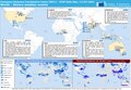
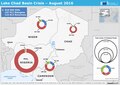 20161025 ECHO LakeChad BokoHaramCrisis.pdf 1,754 × 1,239; 456 KB
-
 20161025 ECHO LakeChad BokoHaramCrisis.png 1,123 × 794; 628 KB
-
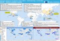
 20161128 ECHO Support IOM II.pdf 1,754 × 1,239; 668 KB
-
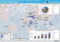
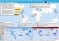
 20161209 ECHO PeopleAffectedConflict 2017 edit.pdf 2,100 × 1,575; 1.29 MB
-
 20161209 ECHO PeopleAffectedConflict 2017 edit.png 1,344 × 1,008; 590 KB
-
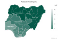 Absolute poverty by zone in Nigeria.svg 600 × 400; 94 KB
-
 Dollar per day poverty by state in Nigeria.svg 600 × 400; 110 KB
-
 Dollar per day poverty by zone in Nigeria.svg 600 × 400; 95 KB
-
 ECDM 20160224 CountriesOfOrigin DailyMap.pdf 1,754 × 1,239; 910 KB
-
 ECDM 20160412 World SevereWeather.pdf 1,625 × 1,125; 598 KB
-
 ECDM 20160413 Lake-Chad-Crisis.pdf 1,754 × 1,239; 348 KB
-
 ECDM 20160608 Diffa region crisis.pdf 1,625 × 1,125; 350 KB
-
 ECDM 20160614 World SevereWeather.pdf 1,625 × 1,125; 555 KB
-
 ECDM 20160713 World SevereWeather.pdf 1,625 × 1,125; 574 KB
-
 ECDM 20160908 World Severe Weather.pdf 1,625 × 1,125; 1.02 MB
-
 ECDM 20160921 World events.pdf 1,625 × 1,125; 669 KB
-
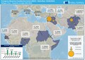
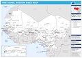 ECHO Sahel Basemap A3 Landscape 2016 v2.pdf 1,754 × 1,239; 492 KB
-
 ECHO Sahel Basemap A3 Landscape 2016 v2.png 1,123 × 794; 557 KB
-
 Food poverty by state in Nigeria.svg 600 × 400; 110 KB
-
 Population density of Nigeria states.png 4,697 × 4,126; 778 KB
-
 Relative poverty by state in Nigeria.svg 600 × 400; 110 KB
-
 Relative poverty by zone in Nigeria.svg 600 × 400; 94 KB


