Category:2010s maps of Louisiana
Jump to navigation
Jump to search
States of the United States: Alabama · Alaska · Arizona · Arkansas · California · Colorado · Florida · Georgia · Hawaii · Indiana · Iowa · Louisiana · Maryland · Massachusetts · Michigan · Missouri · Nebraska · Nevada · New Jersey · New Mexico · New York · North Carolina · Ohio · Oklahoma · Pennsylvania · Tennessee · Utah · Virginia · West Virginia · Wisconsin – Washington, D.C.
Subcategories
This category has the following 3 subcategories, out of 3 total.
- 2010 maps of Louisiana (34 F)
- 2018 maps of Louisiana (4 F)
N
- 2010s maps of New Orleans (2 F)
Media in category "2010s maps of Louisiana"
The following 3 files are in this category, out of 3 total.
-
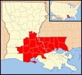
 2016 Louisiana floods map of affected parishes.png 331 × 303; 9 KB
-
-
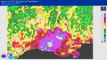 August 9-16, 2016, Louisiana rainfall.png 4,000 × 2,250; 1.45 MB


