Category:2010 in Queensbury, West Yorkshire
Jump to navigation
Jump to search
Media in category "2010 in Queensbury, West Yorkshire"
The following 21 files are in this category, out of 21 total.
-
 Archway with date-stone, Mill Lane, Queensbury - geograph.org.uk - 2273797.jpg 1,499 × 2,000; 549 KB
-
 Black Dyke (4376681848).jpg 3,872 × 2,592; 4.08 MB
-

-
 Fence (4389016939).jpg 2,475 × 1,885; 5.59 MB
-
 Houses - Perseverance Road - geograph.org.uk - 1911047.jpg 640 × 480; 61 KB
-
 Junction of Chapel Street and High Street, Queensbury - geograph.org.uk - 1931574.jpg 2,000 × 1,211; 536 KB
-
 Milestone at Scarlet Heights, Queensbury - geograph.org.uk - 1931553.jpg 2,000 × 1,500; 841 KB
-
 Mill Lane, Mountain, Queensbury - geograph.org.uk - 1931519.jpg 2,000 × 1,462; 513 KB
-
 Mountain (4370351440).jpg 2,447 × 995; 1.49 MB
-
 One House (4777613285).jpg 2,460 × 1,440; 2.33 MB
-
 Queensbury Post Office - geograph.org.uk - 2198766.jpg 2,000 × 1,353; 694 KB
-

-
 Snowy night (5225981301).jpg 1,920 × 2,560; 5.4 MB
-
 The Co-op, Chapel Street, Queensbury - geograph.org.uk - 2198733.jpg 2,000 × 1,307; 476 KB
-

-
 The Pineberry, Queensbury (4710137634).jpg 2,338 × 1,559; 4.43 MB
-
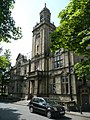 The Victoria Hall, Queensbury - geograph.org.uk - 1931536.jpg 1,500 × 2,000; 826 KB
-
 Thornton Road, Queensbury (4379322910).jpg 2,459 × 1,920; 4.97 MB
-
 Tomb (4376660656).jpg 3,813 × 2,592; 6.16 MB
-
 Tree (4375923173).jpg 1,920 × 2,560; 686 KB
-
 Victoria Hall, Queensbury (4369603147).jpg 2,643 × 2,869; 6.29 MB

.jpg)

.jpg)


.jpg)


.jpg)


.jpg)

.jpg)
.jpg)
.jpg)
.jpg)
.jpg)