Category:19th-century maps of Vendée
Jump to navigation
Jump to search
Subcategories
This category has only the following subcategory.
1
Media in category "19th-century maps of Vendée"
The following 11 files are in this category, out of 11 total.
-
 "Plan géneral des marais salants de Moirmotiers" (4623425869).jpg 3,168 × 2,699; 2.31 MB
-
-

-

-

-
 BassetiereEM.jpg 1,247 × 744; 471 KB
-
 Carte du département de la Vendée - 1860.jpg 12,358 × 8,244; 15.74 MB
-
-
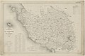
 Dépt. de la Vendée (région de l'ouest) - Fonds Ancely - B315556101 A LEVASSEUR 085.jpg 3,016 × 2,044; 2.02 MB
-
 FMIB 48844 Departement de la Vendee - Carde des Quartiers Maritimes.jpeg 1,034 × 1,561; 303 KB
-

.jpg)
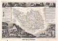
_-_Geographicus_-_Vendee-levasseur-1852.jpg)

.jpg)


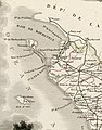
_-_Fonds_Ancely_-_B315556101_A_LEVASSEUR_085_(cropped).jpg)
_-_Fonds_Ancely_-_B315556101_A_LEVASSEUR_085.jpg)

