Category:1920s maps of the Caribbean
Jump to navigation
Jump to search
Subcategories
This category has the following 5 subcategories, out of 5 total.
- 1929 maps of the Caribbean (empty)
B
- 1920s maps of the Bahamas (2 F)
H
P
- 1920s maps of Puerto Rico (8 F)
Media in category "1920s maps of the Caribbean"
The following 4 files are in this category, out of 4 total.
-
 The Banana Its Growth and Cultivation.jpg 11,655 × 8,743; 13.73 MB
-
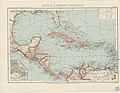 Map Antilles and Central America 1929 - Touring Club Italiano CART-TRC-14.jpg 7,252 × 5,597; 4.81 MB
-
 FMIB 49243 Relief map of the sea and land.jpeg 1,087 × 596; 228 KB
-
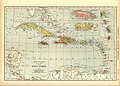 W-INDIES.jpg 3,500 × 2,516; 1.39 MB


