Category:1913 maps of Indiana
Jump to navigation
Jump to search
States of the United States: California · Florida · Georgia · Hawaii · Idaho · Illinois · Indiana · Iowa · Louisiana · Maryland · Massachusetts · Michigan · Minnesota · Missouri · New York · North Dakota · Ohio · Oklahoma · Pennsylvania · South Carolina · Utah · West Virginia · Wisconsin – Washington, D.C.
| ← 1910 1911 1913 1916 1917 1919 → |
Subcategories
This category has only the following subcategory.
Media in category "1913 maps of Indiana"
The following 2 files are in this category, out of 2 total.
-
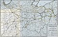 Pennsylvania Lines West of Pittsburgh, Flood of March 1913 (51806780928).jpg 5,548 × 3,499; 14.46 MB
-
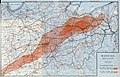 Rainfall, March 23-27, 1913 (51806765503).jpg 6,242 × 3,999; 19.11 MB
.jpg)
.jpg)