Category:1903 maps of the United Kingdom
Jump to navigation
Jump to search
Countries of Europe: Austria · Cyprus‡ · France‡ · Germany · Greece · Norway · Russia‡ · Spain‡ · Turkey‡ · United Kingdom
‡: partly located in Europe
‡: partly located in Europe
Media in category "1903 maps of the United Kingdom"
The following 8 files are in this category, out of 8 total.
-
 Rodd, Nash & Little Brampton, Ordnance Survey Herefordshire X.SE 1886.jpg 1,650 × 1,688; 3.11 MB
-
 Staunton on Arrow Ordnance Survey Herefordshire X.SW 1886.jpg 1,377 × 1,297; 1.51 MB
-
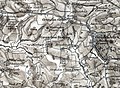 Grendon Bishop detail in OS Hereford (Ludlow) sheet 197 - 1897.jpg 1,232 × 899; 1.4 MB
-
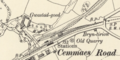 Cemmaes Road map 1900.png 2,866 × 1,430; 4.16 MB
-
 Great and Little Wolford, Warwickshire 1903 map.jpg 743 × 743; 729 KB
-
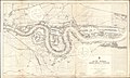 Admiralty Chart No 3337 River Thames London Bridge to Woolwich, Published 1903.jpg 18,805 × 11,282; 88.37 MB
-

-
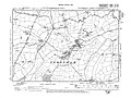 Todenham, Gloucestershire 1903 map.jpg 1,276 × 958; 685 KB

_sheet_197_-_1897.jpg)


