Category:1896 maps of Pennsylvania
Jump to navigation
Jump to search
States of the United States: California · Connecticut · Georgia · Idaho · Illinois · Indiana · Iowa · Kansas · Kentucky · Louisiana · Maine · Massachusetts · Michigan · Minnesota · Mississippi · Missouri · Montana · New Hampshire · New Jersey · New York · North Carolina · North Dakota · Ohio · Oklahoma · Oregon · Pennsylvania · Rhode Island · South Carolina · South Dakota · Tennessee · Texas · Virginia · Washington · West Virginia · Wisconsin · Wyoming – Washington, D.C.
| ← 1890 1891 1892 1893 1894 1895 1896 1897 1898 1899 → |
Subcategories
This category has the following 29 subcategories, out of 29 total.
A
C
D
E
L
M
S
W
Y
Media in category "1896 maps of Pennsylvania"
The following 21 files are in this category, out of 21 total.
-
-

-
 Butler, Butler County, Pennsylvania, 1896. LOC 75694953.jpg 9,440 × 6,272; 14.05 MB
-
 Butler, Butler County, Pennsylvania, 1896. LOC 75694953.tif 9,440 × 6,272; 169.39 MB
-
 Clarion, Clarion County, Pennsylvania 1896. LOC 75694956.jpg 7,456 × 5,096; 10.71 MB
-
 Clarion, Clarion County, Pennsylvania 1896. LOC 75694956.tif 7,456 × 5,096; 108.71 MB
-
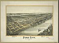 Ford City, Armstrong County Pennsylvania., 1896 LCCN2003681818.jpg 10,019 × 7,298; 10.73 MB
-
 New Castle, Pennsylvania 1896 LOC gm71005367.jpg 12,240 × 6,912; 17.2 MB
-
 New Castle, Pennsylvania 1896 LOC gm71005367.tif 12,240 × 6,912; 242.05 MB
-

-

-

-
 Sanborn Fire Insurance Map from Tionesta, Forest County, Pennsylvania. LOC sanborn08004 002.tif 6,450 × 7,650; 141.17 MB
-

-

-
 Tidioute, Warren County, Pennsylvania 1896 LOC gm71005344.jpg 7,712 × 5,200; 7.94 MB
-
 Tidioute, Warren County, Pennsylvania 1896 LOC gm71005344.tif 7,712 × 5,200; 114.73 MB
-
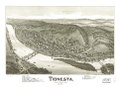
 Tionesta, Forest County, Pa. 1896. LOC 75696546.jpg 5,848 × 4,224; 5.2 MB
-
 Tionesta, Forest County, Pa. 1896. LOC 75696546.tif 5,848 × 4,224; 70.67 MB
-
 Titusville, Pennsylvania 1896. LOC 75696545.jpg 10,784 × 6,720; 16.8 MB
-
 Titusville, Pennsylvania 1896. LOC 75696545.tif 10,784 × 6,720; 207.33 MB
.jpg)
.jpg)


_(14774168894).jpg)
_(14776528785).jpg)


