Category:1875 maps of Massachusetts
Jump to navigation
Jump to search
States of the United States: California · Connecticut · Illinois · Indiana · Iowa · Massachusetts · Michigan · New Jersey · New York · Ohio · Oklahoma · Oregon · Pennsylvania · Tennessee · Texas · Utah · Virginia · Wyoming
| ← 1870 1871 1872 1873 1874 1875 1876 1877 1878 1879 → |
Subcategories
This category has only the following subcategory.
M
Media in category "1875 maps of Massachusetts"
The following 23 files are in this category, out of 23 total.
-
 1875 map of Woburn, Massachusetts.png 3,188 × 2,510; 14.79 MB
-

-
-
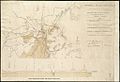
 Centennial map of Concord, 1775-1875 (3369692455).jpg 2,000 × 1,336; 2.46 MB
-
 City of Taunton, Mass - G3764.T2A3 1875B3.jpg 10,320 × 7,464; 60.39 MB
-
 City of Taunton, Mass. 1875. LOC 74693249.jpg 9,872 × 7,088; 15.62 MB
-

-
 Gen. Washingtons Revolutionary campaign war map (2675083506).jpg 2,000 × 1,472; 2.78 MB
-

-
 Map of Boston, for 1875 (3720373761).jpg 847 × 1,024; 806 KB
-
 Map of Boston, showing the new wards (3856484788).jpg 1,841 × 2,000; 2.8 MB
-

-
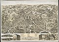
 Northampton, Mass. (2675124667).jpg 2,000 × 1,584; 3.22 MB
-
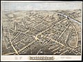
 Reading town of Reading (3855702559).jpg 2,000 × 1,692; 2.8 MB
-
 Taunton station and roundhouse on 1875 bird's eye view map.jpg 1,168 × 780; 237 KB
-

-

-
 View of Springfield, Mass. (2675790314).jpg 9,416 × 7,151; 19.04 MB
-
 View of Springfield, Mass. 1875. LOC 75694606.jpg 11,216 × 8,400; 20.18 MB
-

-

-
 Westfield 1875. LOC 74693244.jpg 8,736 × 6,576; 12.23 MB
-
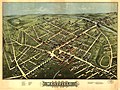
 Westfield, Mass. (2673879763).jpg 2,000 × 1,500; 3.39 MB


.jpg)
.jpg)


.jpg)
.jpg)
.jpg)
.jpg)
.jpg)
.jpg)
.jpg)

.jpg)
.jpg)
.jpg)


.jpg)