Category:1870s maps of Eastern Europe
Jump to navigation
Jump to search
| 19th-century maps of Eastern Europe: ← 1800s 1810s 1820s 1830s 1840s 1850s 1860s 1870s 1880s 1890s → |
Media in category "1870s maps of Eastern Europe"
The following 5 files are in this category, out of 5 total.
-
 Przewodnik praktyczny dla użytku maszynistów (Pietraszek, 1873) Mappa.tif 4,032 × 3,948; 19.91 MB
-
 1874 Mitchell Map of Russia - Geographicus - Russia-m-1874.jpg 3,000 × 2,360; 2.5 MB
-
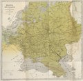
 WALLACE(1877) p1.022 Russia, Population Density.jpg 3,576 × 4,580; 3.92 MB
-
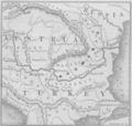 Harper's Map of Danube.jpg 660 × 628; 190 KB
-
 Lithuania. Europe, Asher & Adams, 1874.jpg 1,614 × 718; 418 KB

_p1.022_Russia,_Population_Density.jpg)

