Category:1860s maps of the Russian Empire
Jump to navigation
Jump to search
Subcategories
This category has the following 13 subcategories, out of 13 total.
Media in category "1860s maps of the Russian Empire"
The following 11 files are in this category, out of 11 total.
-

-
-
 1862 Johnson Map of Russia - Geographicus - Russia-johnson-1862.jpg 3,224 × 4,000; 3.43 MB
-
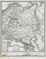 1862 Perthes Map of Russia - Geographicus - Russland-perthes-1862.jpg 2,551 × 3,299; 2.6 MB
-
 Ca. 1863 map - Karte von Russland mit Angabe seiner Erwerbungen seit dem Jahre 1667.djvu 12,165 × 8,239; 4.3 MB
-
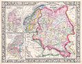
 Ethnic composition of the westernmost parts of the Russian Empire, Erckert, 1863.jpg 2,048 × 1,695; 1.27 MB
-
 Etnograficheskiy atlas Zapadno Russkih gubernij, 1863.jpg 3,624 × 3,000; 4.85 MB
-
 Johnson's map of Russia in 1863.tif 8,308 × 10,808; 185.97 MB
-
 Le Tour du monde-07-p339.jpg 1,570 × 1,072; 415 KB
-
 Tableau Ethnographique (Georg Ferdinand Robert d'Erckert, 1863).jpg 9,049 × 7,321; 8.75 MB
-
 Zentralasien BV042517576.jpg 11,270 × 7,133; 8.33 MB


.jpg)
