Category:1860s maps of New York City
Jump to navigation
Jump to search
Subcategories
This category has the following 7 subcategories, out of 7 total.
- 1865 maps of New York City (1 F)
- 1867 maps of New York City (3 F)
1
Media in category "1860s maps of New York City"
The following 9 files are in this category, out of 9 total.
-

-
-
-
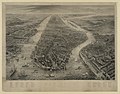
 Annual report of the Board of Commissioners of the Central Park (1858) (18246085158).jpg 5,312 × 2,014; 1.77 MB
-
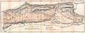
 Annual report of the Board of Commissioners of the Central Park (1858) (18246091118).jpg 5,242 × 1,361; 1.33 MB
-

-
 Miller's new map of the city of New-York. LOC 2015591066.jpg 8,883 × 5,141; 7.56 MB
-
 New York and environs - engraved by R. Kupfer, N.Y. LCCN2006680100.jpg 8,662 × 6,814; 10.27 MB
-
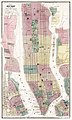
 New York and Vicinity as Proposed to be Remodeled.png 1,289 × 700; 2.43 MB
_-_Geographicus_-_NYC-mitchell-1860.jpg)
.jpg)


,_Harlem,_Washington_Heights,_Inwood_-_Geographicus_-_NYCUpperManhattan-knapp-1868.jpg)
_by_Matthew_Dripps._Original_from_Library_of_Congress._Digitally_enhanced_by_rawpixel._(50623610741).jpg)
_(18246085158).jpg)
_(18246091118).jpg)