Category:1857 maps of India
Jump to navigation
Jump to search
Countries of Asia: People's Republic of China · India · Russia‡
Limited recognition: Taiwan
‡: partly located in Asia
Limited recognition: Taiwan
‡: partly located in Asia
| 1850 1851 1852 1853 1854 1855 1857 1858 1859 → |
English: 1857 maps made in India or from India or showing history of India
Subcategories
This category has only the following subcategory.
Media in category "1857 maps of India"
The following 17 files are in this category, out of 17 total.
-
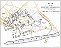
 Map of LUCKNOW - Residency, Palaces, ect.jpg 2,455 × 3,490; 5.48 MB
-
 Atlas over alle Jordens Dele - no-nb digibok 2010021603001-37.jpg 3,930 × 3,106; 2.2 MB
-
 Delhi as it looked just before the Rebellion of 1857.png 3,000 × 2,138; 3.55 MB
-
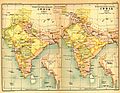
 India north 1857.jpg 1,992 × 1,700; 699 KB
-
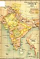
 India1837to1857.jpg 1,232 × 958; 323 KB
-
 Indian revolt of 1857 states map de.svg 990 × 1,115; 610 KB
-
 Indian revolt of 1857 states map-hu.svg 1,639 × 1,852; 347 KB
-
 Indian revolt of 1857 states map.svg 1,639 × 1,852; 347 KB
-
 Kalyan 1857.jpg 1,186 × 1,600; 561 KB
-

-
 Magnus panoramic view map of India (3120958076).jpg 1,503 × 2,000; 2.82 MB
-
 Map BEIC 1857.jpg 612 × 894; 124 KB
-
 Map-sm.jpg 801 × 629; 100 KB
-
 Northern India 1857.jpg 1,992 × 1,700; 2.32 MB
-

-

-


.jpg)


.jpg)
.jpg)