Category:17th-century maps of Madrid
Jump to navigation
Jump to search
Most populous urban areas of the world: Boston [US] · Istanbul [TR] · London [GB] · Madrid [ES] · Mexico City [MX] · Moscow [RU] · New York City [US] · Paris [FR] · Philadelphia [US] · Singapore [SG]
Subcategories
This category has the following 2 subcategories, out of 2 total.
M
T
Media in category "17th-century maps of Madrid"
The following 12 files are in this category, out of 12 total.
-
 Antonio Mancelli - Madrid ca. 1622.jpg 800 × 501; 296 KB
-
 Mancelli-De Witt (1).jpg 4,632 × 3,864; 5.65 MB
-
 Mancelli-De Witt (2).jpg 4,608 × 4,008; 5.97 MB
-
 Plano de Madrid Antonio Mancelli 1622-1635.jpg 2,757 × 1,833; 2.03 MB
-

-
 Corrales de Madrid (Plano de De Witt y Marcelli 1622-1635).jpg 799 × 567; 276 KB
-
 Plano de Madrid (1622-35) det. Corrales de comedias.jpg 798 × 569; 187 KB
-
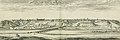
 Plano Teixeira 1656.jpg 427 × 307; 51 KB
-

-
 Madrid 16xx.jpg 8,510 × 2,806; 13.51 MB
-
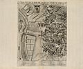
 Plattegrond van Madrid, linkerdeel, BI-1956-1074-65.jpg 5,464 × 7,784; 5.8 MB
-
 Plattegrond van Madrid, rechterdeel, BI-1956-1074-66.jpg 5,454 × 7,614; 5.95 MB

.jpg)
.jpg)

,_RP-P-1954-122.jpg)
.jpg)
_det._Corrales_de_comedias.jpg)

._Salomon_Saury_Fecit_-_btv1b52514232x.jpg)

