Category:1785 maps of the United States
Jump to navigation
Jump to search
Media in category "1785 maps of the United States"
The following 17 files are in this category, out of 17 total.
-
 1785 Cook - Bligh Map of Hawaii - Geographicus - Hawaii-cook-1785.jpg 4,000 × 2,435; 1.64 MB
-

-
-

-

-

-

-
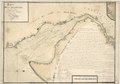
 Hudson's Bay's Country (Peter Pond 1785).jpg 7,287 × 5,560; 3.76 MB
-
 Robert - États-Unis de l'Amérique septentrionale.jpg 3,097 × 2,387; 2.12 MB
-
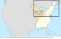
 United States Central change 1785-01-11.png 2,046 × 1,321; 243 KB
-
 United States Central change 1785-04-19.png 2,046 × 1,321; 249 KB
-
 United States Central change 1785-06-00.png 2,046 × 1,321; 245 KB
-
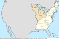 United States Central map 1784-05-12 to 1787-07-13.png 2,000 × 1,320; 249 KB
-

-

-

-


.jpg)


