Category:1780s maps of Massachusetts
Jump to navigation
Jump to search
States of the United States: Alabama · Alaska · Arkansas · California · Connecticut · Delaware · Florida · Georgia · Illinois · Indiana · Kentucky · Louisiana · Maryland · Massachusetts · Michigan · Mississippi · Missouri · Montana · New Hampshire · New Jersey · New York · North Carolina · North Dakota · Ohio · Pennsylvania · Rhode Island · South Carolina · Vermont · Virginia · Wisconsin – Washington, D.C.
Puerto Rico
Puerto Rico
Subcategories
This category has the following 3 subcategories, out of 3 total.
- 1780 maps of Massachusetts (15 F)
- 1781 maps of Massachusetts (7 F)
Media in category "1780s maps of Massachusetts"
The following 3 files are in this category, out of 3 total.
-
 Boston with its environs (35015057572).jpg 2,000 × 1,633; 3.65 MB
-
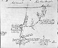 ShaysRebellionMapByEzraStiles.jpg 3,216 × 2,662; 1.8 MB
-
 The Columbian magazine - or, monthly miscellany (3178) (14597575178).jpg 2,982 × 2,002; 1.02 MB
.jpg)

_(14597575178).jpg)