Category:1720 maps
Jump to navigation
Jump to search
| ← · 1720 · 1721 · 1722 · 1723 · 1724 · 1725 · 1726 · 1727 · 1728 · 1729 · → |
Deutsch: Karten mit Bezug zum Jahr 1720
English: Maps related to the year 1720
Español: Mapas relativos al año 1720
Français : Cartes concernant l’an 1720
Русский: Карты 1720 года
Subcategories
This category has the following 7 subcategories, out of 7 total.
Media in category "1720 maps"
The following 113 files are in this category, out of 113 total.
-
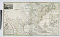
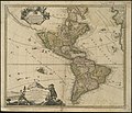
 1720 Chatelain Map of North America - Geographicus - Amerique-chatelain-1720.jpg 4,000 × 3,200; 2.16 MB
-

-
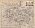 1720 Map of the West Indies with the Adjacent Coasts of North and South America (Bowen).jpg 9,010 × 7,447; 15.36 MB
-
 1720. The middle of Right-bank Ukraine.png 1,029 × 878; 1.73 MB
-
 1769 edition of the 1720 map of the Principality of Catalonia by Josep Aparici i Fins.jpg 15,941 × 14,167; 44.73 MB
-

-

-
 A new map of Great Britain according to the newest and most exact observations (8342715024).jpg 8,150 × 13,086; 102.74 MB
-

-

-
-

-

-

-

-

-

-
 Accurata Utopiae Tabula (FL173085858 3423220).jpg 14,542 × 12,906; 231.2 MB
-
 Adam Friedrich Zürner, Africæ in Tabula Geographica Delineatio (FL35470337 2498317).jpg 14,789 × 12,809; 260.77 MB
-
 Adam Friedrich Zürner, Asiae in Tabula Geographica Delineatio (FL27958471 2486975).jpg 16,004 × 13,657; 313.62 MB
-

-
 Antoine Augustin Calmet, Carte de la Terre Promise (FL60904474 2368438).jpg 7,400 × 13,570; 115.14 MB
-
 Asiae Peninsula sive Asia intra Taurum, 1720 (Weigel).jpg 4,782 × 3,850; 3.89 MB
-
 Aubry de La Motraye, Black Sea (FL36554634 2525109).jpg 9,662 × 8,755; 120.87 MB
-

-

-
 Bowen - Britannia Depicta (Berkshire).jpg 716 × 1,023; 695 KB
-
 Bowen - Britannia Depicta (The West Riding of Yorkshire).jpg 692 × 1,004; 655 KB
-
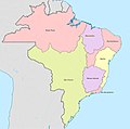 Brasil 1720.jpg 606 × 599; 54 KB
-
 Cagayan River 1720.png 508 × 356; 340 KB
-

-

-
-

-
-

-

-
 Christoph Weigel the Elder, Insulae Maltae nova et accurata tabula (FL13722397 2471733).jpg 7,628 × 6,285; 69.59 MB
-
 Christoph Weigel the Elder, Palaestinae quatuor facies (FL44436227 2369142).jpg 9,162 × 12,818; 86.6 MB
-

-

-

-
-
 Corfou 1720.jpg 2,500 × 2,156; 1.51 MB
-

-
 Ducatus Stiriae Novissima tabula 1720.jpg 3,747 × 3,202; 2.39 MB
-
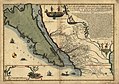
 Fer - La Californie ou Nouvelle Caroline.png 1,024 × 712; 1.46 MB
-

-
-
 Gerard van Keulen, De Baay en Stadt van Gibralter (FL13722354 2471546).jpg 10,693 × 9,183; 133.3 MB
-

-
 Guillaume Delisle, Plan de la Ville et Fauxbourgs de Paris, 1720 - David Rumsey.jpg 8,375 × 6,339; 19.74 MB
-

-

-
-
 Henri Abraham Chatelain, Nouvelle carte de L'Asie (FL27961771 2487489).jpg 14,700 × 12,383; 238.49 MB
-

-
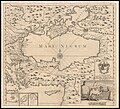
 Henri Michelot, Nouvelle carte generalle de la Mer Mediterranee (FL13730102 2628622).jpg 21,761 × 9,259; 280.98 MB
-
 Het Aanzien van het Moabietische Landt (FL37124217 3899697).jpg 4,788 × 2,774; 4.73 MB
-
 Het Beloofde Landt Canaan door wandelt van Iesu Christo neffens syne Apostelen (FL36566023 3901865).jpg 11,475 × 7,779; 123.22 MB
-
 Hotel-de-Blossac---1720.svg 311 × 320; 235 KB
-
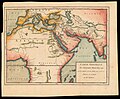 Humphrey Prideaux, Carte generale des anciennes monarchies (FL13736811 2718536).jpg 6,781 × 5,578; 52.34 MB
-
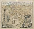
 Italy and surrounding countries (FL83240476 2589084).jpg 10,620 × 7,608; 88.23 MB
-
 Joachim Ottens, Le Royaume De Siam Avec Les Royaumes Qui Luy Sont Tributaires (FL25569902 2467587).jpg 15,006 × 11,019; 223.14 MB
-
-

-

-

-

-
 Johann Baptist Homann, Planiglobium Terrestre Minus (FL80427953 2725387).jpg 11,100 × 9,006; 109.99 MB
-
-
 Johann Christoph Haffner, Hierosolyma (FL6880199 2368069).jpg 3,900 × 1,575; 4.28 MB
-
 Johannes Henricus Coccejus, Ierusalem aus den Schrifften Iosephi (FL6881502 2368012).jpg 2,700 × 2,301; 2.89 MB
-

-
 John Senex, A map of Greece with part of Anatolia (FL35072637 2533223).jpg 15,103 × 12,848; 272.23 MB
-
 John Senex, A map of Hungary and countries adjacent (FL35075116 2540408).jpg 14,115 × 11,775; 251.46 MB
-
 Juan Bautista Villalpando, Ierusalem (FL51386066 2476330).jpg 10,885 × 9,123; 135.94 MB
-
 Karta över Gävle med omgivningar, från 1720-talet - Skoklosters slott - 97970.tif 4,408 × 3,437; 43.36 MB
-
-

-

-

-
 Luristan in 1720.jpg 828 × 746; 474 KB
-
 Map - Special Collections University of Amsterdam - OTM- HB-KZL 33.17.15.tiff 7,336 × 6,410; 134.54 MB
-

-
-
 Matthäus Seuttetre, Milazzo (FL167468628 2464082).jpg 14,584 × 12,651; 259.32 MB
-
 Matthäus Seuttetre, Nova et accuratissima Maris Caspii (FL37810835 3151786).jpg 16,111 × 13,846; 306.64 MB
-
 Moulin de Cresnay .jpg 577 × 673; 77 KB
-
 Mullerova mapa Cech 12.jpg 6,818 × 5,903; 15.65 MB
-
 Nicolas de Fer, L'Afrique (FL35470155 2496834).jpg 15,793 × 12,415; 269.54 MB
-
 Nicolas Sanson, Romani imperii qua oriens est descriptio geographica (FL27969763 2719532).jpg 16,427 × 12,862; 278.42 MB
-
 Nicolas Sanson, Ægyptus Antiqua, divisa in Nomos (FL25570255 2502030).jpg 13,200 × 15,622; 274.99 MB
-
 Pieter van der Aa, L'Inde de la Gange (FL27936007 2467373).jpg 8,723 × 6,019; 68.51 MB
-
 Pieter van der Aa, La Chine (FL25569895 2467602).jpg 8,892 × 5,946; 69.28 MB
-
 Pieter van der Aa, Moscou (FL39695601 2370019).jpg 8,974 × 7,454; 99.12 MB
-
 Plan de la Ville et Citadelle de Dunkerque (FL167548111 0934957).jpg 14,219 × 10,041; 197.75 MB
-
 Plan du Cul de Sac de Quebec a mer basse.png 1,014 × 537; 1.03 MB
-
-
 PlanvonMemmingen.JPG 1,339 × 993; 268 KB
-
-
 1720 De La Feuille Map and View of Gibraltar - Geographicus - Gibraltar-lafeuille-1720.jpg 5,549 × 2,230; 2.61 MB
-
 StadtCB1720 Wendische Kirche.jpg 700 × 549; 107 KB
-
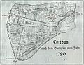 StadtCB1720.jpg 700 × 549; 114 KB
-
-

-

-
 The harbour of Casco Bay and islands adjacent (9492652503).jpg 799 × 638; 117 KB
-
-
 USVI - St. John - Coral Bay - Map from 1720.jpg 6,831 × 5,525; 3.89 MB
-

-
 Weihnachtsflut 1717.jpg 985 × 811; 432 KB
-


.jpg)


.jpg)
,_Canada,_and_New_France_with_ye_adjoining_territories_of_England_and_Spain_-_to_LOC_2001624907.jpg)
.jpg)


.jpg)
.jpg)
.jpg)

.jpg)
.jpg)
.jpg)
.jpg)
.jpg)
.jpg)
.jpg)


_(14576023458).jpg)
.jpg)
.jpg)
.jpg)
.jpg)
.jpg)
.jpg)
.jpg)


.jpg)


.jpg)
.jpg)
.jpg)
.jpg)

.jpg)
.jpg)
.jpg)
.jpg)
.jpg)
.jpg)
.jpg)
.jpg)

.jpg)
.jpg)
.jpg)


.jpg)
.jpg)
.jpg)
.jpg)
.jpg)
.jpg)
.jpg)
.jpg)
.jpg)
.jpg)


.jpg)
.jpg)


.jpg)
.jpg)
.jpg)
.jpg)
.jpg)
.jpg)
.jpg)


.jpg)
.jpg)

.jpg)

.jpg)
.jpg)