Category:1700s maps of Grand Duchy of Lithuania
Jump to navigation
Jump to search
Media in category "1700s maps of Grand Duchy of Lithuania"
The following 5 files are in this category, out of 5 total.
-
 Karta över Polen, från 1700-talet - Skoklosters slott - 97979.tif 4,327 × 3,567; 44.18 MB
-
 Carte des Estats de Suede, de Dannemarq, et de Pologne; sur la Mer Baltique.jpg 2,882 × 3,576; 5.12 MB
-
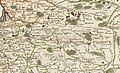
 Lithuanie 1700.jpg 1,280 × 932; 373 KB
-
 Litva. Літва (J. Müller, 1702).jpg 971 × 871; 383 KB
-


.jpg)
_is_clearly_separated_with_a_green_line_from_Samogitia_(Samogitie),_and_the_Belarusian_territories_of_the_Grand_Duchy_of_Lithuania_(Russie_Blanche_ou_Lituanique).jpg)