Category:1450s maps of Europe
Jump to navigation
Jump to search
Subcategories
This category has the following 7 subcategories, out of 7 total.
Media in category "1450s maps of Europe"
The following 3 files are in this category, out of 3 total.
-
 1450 ¿ Carta Catalana jpeg copy.A.jpg 2,696 × 1,519; 1.23 MB
-
 1455 Nautical Chart by Bartolomeo Pareto.jpg 6,065 × 2,982; 5.67 MB
-
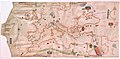
 FraMauroMapEurope.jpg 600 × 415; 132 KB


