Category:Łabski Szczyt
Jump to navigation
Jump to search
Čeština: Violík neboli Labský štít
Polski: Łabski Szczyt
Deutsch: Veilchenstein
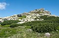
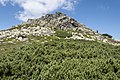
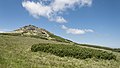
peak in the Karkonosze Mountains on the border of Poland and the Czech Republic with a height of 1471 m above sea level  | |||||
| Upload media | |||||
| Instance of | |||||
|---|---|---|---|---|---|
| Part of |
| ||||
| Located in protected area | |||||
| Location |
| ||||
| Mountain range | |||||
| Elevation above sea level |
| ||||
 | |||||
Subcategories
This category has only the following subcategory.
S
- Schronisko Pod Łabskim Szczytem (15 F)
Media in category "Łabski Szczyt"
The following 23 files are in this category, out of 23 total.
-
 2015 Łabski Szczyt, Karkonosze, Sudety 1.jpg 3,690 × 2,396; 7.97 MB
-
 2015 Łabski Szczyt, Karkonosze, Sudety 2.jpg 3,417 × 2,276; 7.19 MB
-
 2015 Łabski Szczyt, Karkonosze, Sudety 3.jpg 3,667 × 2,064; 5.43 MB
-
 2017 Veilchenstein.jpg 4,032 × 3,024; 5.17 MB
-
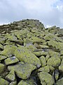 Gołoborze na Łabskim Szczycie.jpg 1,920 × 2,560; 1.79 MB
-
 Harrachovy kameny, řopík (01).jpg 3,648 × 2,736; 4.44 MB
-
 Krkonoše (14).jpg 2,816 × 1,383; 2.79 MB
-
 Krkonoše (16).jpg 2,816 × 1,548; 3.73 MB
-
 Krkonoše-cesta-na-Violík-od-Vysokého-kola2009.jpg 4,288 × 2,848; 6.86 MB
-
 Krkonoše-Labská-bouda-Violík-a-Wawel2009.jpg 4,288 × 2,848; 6.92 MB
-
 Krkonoše-Violík-kameny-na-vrcholu2009.jpg 4,288 × 2,848; 6.3 MB
-
 Labski Szczyt.jpg 3,456 × 2,304; 2.7 MB
-
 Peak of Labski Szczyt.jpg 2,560 × 1,440; 2.23 MB
-
 Schreiberhau-Kamm-Blick-6.jpg 5,556 × 2,509; 3.21 MB
-
 Szklarska Poręba - Karpacz 14 - panoramio.jpg 3,648 × 2,056; 3.55 MB
-
 Szklarska Poręba - Karpacz 16 - panoramio.jpg 3,648 × 2,056; 3.58 MB
-
 Veilchenstein (Retusche).jpg 2,432 × 1,616; 1.66 MB
-
 Veilchenstein summit.jpg 2,904 × 1,927; 2.22 MB
-
 Veilchenstein.jpg 2,430 × 1,572; 1.52 MB
-
 Widok na Łabski Szczyt i Szrenicę w głębi od Snieżnych Kotłów.JPG 4,000 × 1,540; 3.64 MB
-
 Łabski Szczyt 1.jpg 1,200 × 900; 1.02 MB
-
 Łabski Szczyt od strony Szrenicy.JPG 4,000 × 2,762; 6 MB
-
 Łabski Szczyt.JPG 4,000 × 3,000; 6.87 MB


.jpg)
.jpg)
.jpg)


.jpg)


