Category:Île Boishébert
Jump to navigation
Jump to search
This category is for a cultural heritage site in Canada, number 1169
|
This category is for a cultural heritage site in Canada, number 7650
|
 |
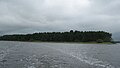
Français : Le lieu historique national du Canada Boishébert est une zone boisée contenant les vestiges archéologiques d’un camp de réfugiés acadiens du 18e siécle à la pointe Wilsons et sur l’île Beaubears, au confluent des rivières Miramichi Sud-Ouest et Nord-Ouest au Nouveau-Brunswick. La reconnaissance officielle vise la zone de la pointe Wilsons qui a été délimitée au moment de la désignation.
Le lieu historique national du Canada de la Construction-Navale-à-l'Île-Beaubears comprend environ 24 hectares (60 acres) de terrain sur la rive sud-est (aval) de l'île Beaubears, au confluent des rivières Miramichi Sud-Ouest et Nord-Ouest, ainsi que le chenal sud adjacent de la rivière Miramichi. L'endroit renferme les vestiges d'un chantier naval du 19e siècle.
English: Boishébert National Historic Site of Canada is a wooded area with archaeological evidence of an 18th century Acadian refugee camp situated on Wilsons Point and Beaubears Island at the confluence of the Southwest and Northwest Miramichi River in New Brunswick. Official recognition refers to the area of Wilsons Point delineated at the time of designation.
Beaubears Island Shipbuilding National Historic Site of Canada incorporates some 24 hectares (60 acres) on the southeastern (downstream) shore of Beaubears Island at the confluence of the Southwest and Northwest Miramichi River, and the adjacent south channel of the Miramichi River. The site includes the remains of an early 19th-century shipyard.
human settlement in Derby Parish, New Brunswick, Canada  | |||||
| Upload media | |||||
| Instance of | |||||
|---|---|---|---|---|---|
| Location | Derby Parish, Northumberland County, New Brunswick, Canada | ||||
| Heritage designation |
| ||||
| official website | |||||
 | |||||
Subcategories
This category has only the following subcategory.
E
Media in category "Île Boishébert"
The following 3 files are in this category, out of 3 total.
-
 Beaubears Island.JPG 2,272 × 1,280; 640 KB
-
 Monument Grand Dérangement.JPG 1,600 × 1,200; 644 KB
-
 Île Boishébert de la pointe Wilson.JPG 1,600 × 1,200; 586 KB


Categories:
- National Historic Sites of Canada by name
- National Historic Sites of Canada in New Brunswick
- Acadian sites designated as National Historic Sites of Canada
- Natural heritage sites designated as National Historic Sites of Canada
- Industrial buildings designated as National Historic Sites of Canada
- Archaeological sites designated as cultural heritage monuments in Canada
- Shipyards in Canada
- Islands of New Brunswick
- Miramichi River
- Miramichi, New Brunswick
- Cultural heritage monuments in Northumberland County, New Brunswick