Bridges in Seattle
Jump to navigation
Jump to search
Wikimedia category | |||||
| Upload media | |||||
| Instance of | |||||
|---|---|---|---|---|---|
| Category combines topics | |||||
| Seattle | |||||
city in and county seat of King County, Washington, United States     | |||||
| Pronunciation audio | |||||
| Instance of | |||||
| Named after | |||||
| Location | King County, Washington, Pacific Northwest, Washington, Pacific States Region | ||||
| Located in or next to body of water | |||||
| Legislative body | |||||
| Head of government |
| ||||
| Inception |
| ||||
| Population |
| ||||
| Area |
| ||||
| Elevation above sea level |
| ||||
| Different from | |||||
| official website | |||||
 | |||||
Bridges across the Lake Washington Ship Canal[edit]
From west to east.
-
 BNSF Railway bridge (Salmon Bay Bridge), west of Chittenden Locks
 -
 Ballard Bridge
 -
 Fremont Bridge open
 -
 Fremont and Aurora Bridges
 -
 Aurora Bridge (officially George Washington Memorial Bridge) during the 1992 Summer Solstice Parade
 -
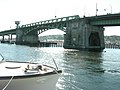
 University Bridge and Interstate 5 Ship Canal Bridge
 -
 Remnant of an old gate - intended to stop traffic when the bridge is open - on the University Bridge
 -
 Montlake Bridge
 -
 Montlake Bridge south tower


_from_east_01.jpg)


Bridges over the Duwamish Waterway[edit]
From south to north
-
 Old South Park Bridge (demolished 2010–2011)
 -
 New South Park Bridge (opened 2014)
 -
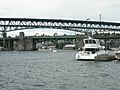
 Looking down the Duwamish Waterway from the South Park Bridge to the First Avenue Bridge. The latter is open here.
 -
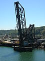 Railway bridge over Duwamish Waterway, seen here looking south from the West Seattle Bridge
 -
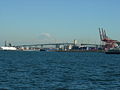
 West Seattle Bridge over Duwamish Waterway; railway bridge can be seen in background
 -
 West Seattle Bridge


Bridges over Lake Washington and its bays[edit]
-
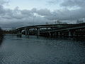
 The two bridges that carry Interstate 90 across Lake Washington
 -
 Bicycling across Lake Washington on I-90
 -
 State Route 520 over Union Bay


Other Seattle bridges[edit]
-
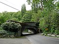
 N. Queen Anne Dr. Bridge over Wolf Creek Canyon
 -
 Cowen Park Bridge (NE 15th Street)
 -
 Ravenna Park Bridge (NE 20th Street)
 -
 Jose P. Rizal Bridge (12th Avenue S.)
 -
 Arboretum Sewer Trestle
 -
 Schmitz Park Bridge
 -
 The former Leschi Park trolley bridge


Former bridges[edit]
-
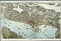 1891 map showing several trestle bridges on Elliott Bay, including an east-west bridge north of the area where Harbor Island would later be constructed.
 -
 A different alignment in that area, 1916. This is looking east along SW Spokane Street toward Pigeon Point. None of this is water nowadays.
 -
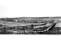
 1905 photograph showing some of those trestle bridges.
 -
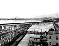
 Earlier bridges near the site of the present-day Ballard Bridge (shown here in 1902, when Salmon Bay was still tidal; view from the south). The bridge on the right is aligned with NW 14th Street, not NW 15th (the alignment of the present-day bridge)
 -
 The South Canal trestle and Grant St Bridge (shown here in 1901; view from the south) ran north-south near the foot of Beacon Hill, in what would soon be filled in and become the Industrial District
 -
 The West Wheeler Street Bridge across Interbay (shown here in 1914; view from the east)
 -
 Stone Way Bridge, predecessor of the present-day Aurora Bridge (shown here in 1916; view from the east)

.jpeg)

.jpeg)
.jpeg)
.gif)
.jpeg)