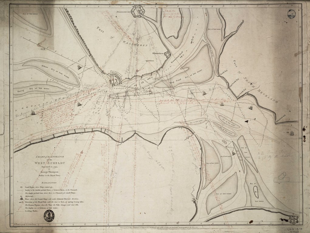
File:Chart of the entrance of the West Scheldt surveyed in 1794, by George Thompson Master in the Royal Navy. RMG F0350.tiff

Original file (7,484 × 5,628 pixels, file size: 120.51 MB, MIME type: image/tiff)
Captions
Captions
Summary[edit]
| Author |
Alexander Dalrymple; Hydrographical Office |
| Description |
English: Chart of the entrance of the West Scheldt surveyed in 1794, by George Thompson Master in the Royal Navy.Single sheet. Engraving. Scale [circa1:45,000 (bar)]. Borders graduated for latitude and longitude from the meridian of Greenwich. Sandbanks and soundings are shown and fortifications at Flushing and Middleburg are marked. Contains an explanation of symbols.
The chart was heavily annotated by its owner, Captain Nicholas Tomlinson, who sent the Admiralty a plan for attacking the French fleet there - see G218:4/19. |
| Date | 1801 |
| Dimensions | Printed area 48.5 x 64.5cm, on sheet 52 x 69cm. |
| Source/Photographer | http://collections.rmg.co.uk/collections/objects/540363 |
| Permission (Reusing this file) |
The original artefact or artwork has been assessed as public domain by age, and faithful reproductions of the two dimensional work are also public domain. No permission is required for reuse for any purpose. The text of this image record has been derived from the Royal Museums Greenwich catalogue and image metadata. Individual data and facts such as date, author and title are not copyrightable, but reuse of longer descriptive text from the catalogue may not be considered fair use. Reuse of the text must be attributed to the "National Maritime Museum, Greenwich, London" and a Creative Commons CC-BY-NC-SA-3.0 license may apply if not rewritten. Refer to Royal Museums Greenwich copyright. |
| Identifier | Acquisition Number: N 9363 id number: G218:4/18 |
| Collection | Charts and maps |
Licensing[edit]
|
This is a faithful photographic reproduction of a two-dimensional, public domain work of art. The work of art itself is in the public domain for the following reason:
The official position taken by the Wikimedia Foundation is that "faithful reproductions of two-dimensional public domain works of art are public domain".
This photographic reproduction is therefore also considered to be in the public domain in the United States. In other jurisdictions, re-use of this content may be restricted; see Reuse of PD-Art photographs for details. | ||||
File history
Click on a date/time to view the file as it appeared at that time.
| Date/Time | Thumbnail | Dimensions | User | Comment | |
|---|---|---|---|---|---|
| current | 22:45, 27 August 2017 |  | 7,484 × 5,628 (120.51 MB) | Fæ (talk | contribs) | Royal Museums Greenwich Charts and maps, http://collections.rmg.co.uk/collections/objects/540363 |
You cannot overwrite this file.
File usage on Commons
The following page uses this file: