Deutsch: Streifzug durch die Welt der Karten auf Commons
English: Foray into the world of maps on Commons
Français : excursion à travers le monde des cartes sur Commons
中文:遊覽 Commons 上的地圖世界
English: Hi! I hope that this page will help creators and users of maps to see the possibilities in categorizing maps within Commons, which also makes them easier to find. (You are welcome to help translating this page to more languages) Reconstructed world map of Hecataeus of Miletus
Deutsch: Hi! Auf dieser Seite möchte ich Erstellern und Nutzern von Karten die Möglichkeiten aufzeigen, wie sie Karten in Commons kategorisieren (und dadurch leichter auffindbar machen) können. Rekonstruierte Weltkarte des Hekataios von Milet
Français : Salut! J'espère que cette page aidera les créateurs et les utilisateurs de cartes à voir les possibilités de catégorisation des cartes au sein de Commons, ce qui les rendra également plus faciles à trouver. (Vous êtes invités à aider à traduire ce page ici en français.) Carte du monde reconstituée d'Hécatée de Milet
العربية: آمل أن تساعد هذه الصفحة منشئي الخرائط ومستخدميها في رؤية إمكانيات تصنيف الخرائط ضمن كومنز، مما يسهل أيضًا العثور عليها. (نرحب بمساعدتكم في ترجمة هذه الصفحة إلى اللغة العربية.) خريطة العالم المُعاد بناؤها لهيكاتيوس ميليتوس
Українська: Привіт! Я сподіваюся, що ця сторінка допоможе творцям і користувачам карт побачити можливості категоризації карт у Commons, що також полегшить їх пошук. (Ви можете допомогти перекласти цю сторінку українською.) Реконструйована карта світу Гекатея Мілетського
Español: ¡Hola! Espero que esta página ayude a los creadores y usuarios de mapas a ver las posibilidades de categorizar mapas dentro de Commons, lo que también los hace más fáciles de encontrar. (Le invitamos a ayudar a traducir esta página al español.) Mapa mundial reconstruido de Hecataeus de Mileto
Italiano: Ciao! Spero che questa pagina aiuti i creatori e gli utenti di mappe a vedere le possibilità di categorizzare le mappe all'interno di Commons, il che le rende anche più facili da trovare. (Sei invitato a contribuire alla traduzione di questa pagina in italiano.) Mappa del mondo ricostruita di Ecateo di Mileto
The most important information are, in this order: What, Where, When (and often: Who). These infos should all be included in file name, description page or category, and better in several of those.
by subject: What is shown? Is it a scientific map (geology, meteorology), a historical map (old, or showing history) or a locator map? (marking points of interest in an area). See more about "subject" further below.
by area: Where is the place that the map shows? One can distinguish between world maps, continental, national, provincial and city maps, as well as many steps between those scales. See more about "area" further below.
by time: When was the map created, and which timeframe is displayed? Creation years are important with older maps, and files should ideally named by year (or decade/century) if possible. This is less important with new, self-created maps, except when information will soon be outdated. Many maps also show situations of the past, which is also important to include. See more about "time" further below.
by source: Who created or published the map. This is important, if multiple maps originate from the same source: institutions or authors, but sometimes also wiki editors. If there is a whole map series (e.g. from a book or website), then it's often possible to generate subcategories. There are also map collections who digitize huge amounts of maps. See more about "source" further below.
Optional:
By language Sprache: In which languages were the labels written? Latin, English, Suaheli? Multiple languages? This attribute is especially interesting if the map is not written in the countries' language, or if it's a language in which not many maps exist. Can be used for all maps, including "neutral" ones without text. For some reason, most maps don't have such a category, especially English ones: Only you can change that.
by cardinal direction: This is only of interest with maps that are not oriented northwards.
by material: maps that were not drawn digitally or on paper or parchment, but directly on walls or floors, are often to be regarded as artwork. Possible material are wood, stone, metal, concrete and even smaller objects in case of mosaics.
by surroundings: are photos showing more than just the map, what's the human interaction?
by projection: This is often unimportant. But with unusual projections (example) this is an interesting attribute to know. Furthermore, world and contintal-scale maps ("small-scale maps") also can benefit from this detail. This is however mostly of a particular interest for the cartographers and geographers themselves. See more about "projection" further below.
by (cartographic) method: This is again mostly of internal interest for map science. Just know that "bad maps" are often based on correct data but use the wrong methods to display information - sometimes intentionally for propaganda, but often due to incompetence. See more about "method" further below.
by scale: This attribute is often not very meaningful, a major exception are large-scale and topographic map series.
Deutsch:
DE: Allgemeine Empfehlungen
Die folgenden Informationen sind, in dieser Rangfolge, besonders wichtig: Was, Wo, Wann (und oft: Wer). Diese Infos bitte in Dateinamen, Beschreibungsseiten oder Kategorie darlegen, besser in mehreren davon.
Nach Thema: Was wird gezeigt? Ist es ein wissenschafliches Thema, z.B. Geologie oder Ökonomie? Ist es eine historische Karte, und wird Geschichte gezeigt, oder ist es bloß eine alte Karte? Ist es eine Lokalisierungskarte, die bestimmte Punkte markiert? Siehe mehr zu "Thema" weiter unten.
Nach Ort: Wo liegt das gezeigte Gebiet bzw. der Kartenausschnitt? Unterscheidbar sind Welt-, Kontinental-, National-, Provinz- oder Stadtkarten, sowie viele Abstufungen dazwischen. Siehe mehr zu "Ort" weiter unten.
Nach Zeitraum: Wann ist die Karte entstanden, und welchen Zeitraum zeigt sie? Das Herstellungsjahr ist bei älteren Karten wichtig, und sollte über Nennung von Jahr/Jahrzehnt/Jahrhundert im Dateinamen erfolgen. Bei neuen, selbst erstellten Karten ist das weniger wichtig... es sei denn dass die dargestellten Informationen rasch veralten können. Viele Karten zeigen auch eine Situation, wie sie in der Vergangenheit war: Auch das ist wichtig zu nennen. Siehe mehr zu "Zeitraum" weiter unten.
Nach Kartenhersteller: Wer hat die Karte erstellt oder publiziert. Das ist dann wichtig, wenn viele Karten von derselben Quelle stammen: Institution/en oder Autor/en, aber z.T. auch Wiki-Autoren. Wenn es eine ganze Kartenserie (z.B. aus einem Buch, oder von einer Webseite) gibt, dann kann man ggf. auch entsprechende Unterkategorien bilden. Außerdem gibt es Kartensammlungen, die raue Mengen an Karten digitalisieren. Siehe mehr zu "Hersteller" weiter unten.
Optional:
Nach Sprache: In welchen Sprachen sind die Kartentexte verfasst? Latein, Englisch, Suaheli? Dieses Attribut ist besonders interessant, wenn es sich nicht um die Landessprache handelt, oder es eine Sprache ist, in der bislang wenig Karten existieren - es kann aber überall vergeben werden, einschließlich "neutralen" Karte ohne Text.
Nach Ausrichtung: Bitte nur gesondert angeben, wenn die Karte nicht bereits nach Norden ausgerichtet ist.
Nach Material. Karten, die nicht digital oder auf Papier oder Pergament gezeichnet wurden, sondern z.B. direkt auf Wände, oder Fußböden, sind meist als Kunstwerke einzustufen. Werkstoffe können Holz, Stein, Metall und Beton sein, oder bei Mosaiken auch Teilobjekte.
Nach Umgebung: zeigen Fotos mehr als nur die Karte, gibt es menschliche Interaktion und welche?
Nach Karten-Projektion: Das ist häufig unwichtig. Aber besonders bei ungewöhnlichen Projektionen (Beispiel) sollte dieses Merkmal genannt werden, wenn bekannt. Auch für Welt- und Kontinentalkarten ("kleinmaßstäbige Karten") ist dies als Detailangabe hilfreich. Interessant ist das aber vor allem für Kartografen und Geografen. Siehe mehr zu "Projektion" weiter unten.
nach kartographischer Methodik: Auch das ist ein Merkmal, das vor allem für die Kartenwissenschaft selbst interessant it. Es genügt zu wissen, dass "schlechte Karten" oft auf richtigen Daten beruhen, aber eine falsche Methodik anwenden, um diese darzustellen. Das ist gelegentlich propagandistische Absicht, aber häufig einfach nur Unvermögen. Siehe mehr zu "Methodik" weiter unten.
Nach Maßstab: Dieses Merkmal hat bei einzelnen Karten sehr wenig Aussagekraft, ist aber bei großmaßstäbigen und topographischen Kartenserien von Interesse.
Русский: в настоящее время недоступно, попробуйте английскую версию.
Maps can either be purely "topographic" (describing the area) or be "thematic" (showing a theme/topic within the area). The first major grouping of map subjects here is generally topographic.
Subject: None. Blank maps are the most barebone of maps and usually only show coastlines and maybe a map grid, but often also country borders (or subdivision borders). These maps are often well-suited to create new thematic maps of a subject of your choice (see further below). Note that there are also Category:Outline maps which are so barebone and blank that they are usually not well-suited to build upon.
Subject: Showing an area, often without labels. May include topographic or hydrographic information (see below) but otherwise "just" an improved blank map. These maps are great to use with templates, because skilled users can place a variable dot on top of this map, to show where the location of a geographical article is. This method eliminates the need to create a new locator map (see below) for that location. Note: Location maps are never Locator maps.
Subject: One single dot placed in an otherwise (mostly) blank map, to locate the subject within the borders of an area. Please don't create more of these maps, and use location maps and variable templates for this kind of content (see above). May thematically overlap with "Maps of subdivisions of..."
Subject: One specific area highlighted in an otherwise (mostly) blank map, to locate the subject within the borders of an area. This may be actually useful, as long as you create a complete series of all the sub-areas of the chosen area, with the intent to place them in articles. You should prepare them in an identical manner and keep to a naming scheme, like in the provided examples. (Make sure that nobody else already created a similar series!) For categorizing: Locator maps are available for each country, and then are broken down by subdivisions. Note: Locator maps are never Location maps.
Subject: Special cases of locator maps. "Bilateral maps" are about locating two different countries in world maps; please always use both "Category:Bilateral maps of country A" and "... of country B" and also insert "Category:Relations of A and B" (the relations get always sorted alphabetically: there is no category of "Relations of B and A). If the map is in the "globe scheme", please indicate that with the best fitting, corresponding category.
Subject: One specific road line, located within an area or a larger network of roads. Strictly spoken, these maps are of the "locator map" type, but for practical reasons, they are usually found as "Road maps of..." or "Road transport maps of...", often as part of "Transport maps of...". The same can be applied to individual Rail transport maps of... Note that there is a substantial overlap with the next row, and these cannot be cleanly separated.
Subject: Networks of roads, railroads and highways. Please note that many of the rail and road transport map categories were originally under local naming schemes, so there are older categories like "Street maps of...", "Railroad maps of..." and "Railway maps of..." etc. The best way to find the correct category is by going to the "Category:Transport maps of <country>" level (which should always exist) and find which sub-structure applies. (Harmonizing this is a major to-do, and may require further discussion)
Subject: Public transport maps, intended for orientation of passengers. Examples show a schematizes and a to-scale version. If such maps exist for a region or city, they should be placed under "Public transport maps of..." and only then subcategorized into "Bus maps...", "Tram maps..." and "Metro maps..." if that becomes necessary.
Subject: OSM maps of a country or region. Because of cooperation of OSM and Wikimedia (WikiMap project) it is not strictly necessary to upload rendered maps from OSM anymore (one can show map areas in an interactive template within WP articles, for example). However, OSM may also be used as background for thematic maps. If the result visibly shows the OSM background, then the OSM-category (... of <country or subdivision> should be applied together with the thematic map. If the map is "just" the OSM, then still please also include "Category:Map of <city>" or "Category:<village>" to make clear what the cutout shows. Large cities may have dedicated OSM categories already.
Subject: Small-to-medium-scale topographic maps (usually with relief and no other information). Should not be categorized here if it's just a basemap for another subject layer. Should get sorted additionally by area (largest applicable administrative subdivision). Other categories usually optional.
Subject: Large-to-medium-scale topographic maps (usually not with a too strong relief, and much detailed information of roads and cities). Should not be categorized here if it's just a basemap for another subject layer. Should get sorted additionally by area (largest applicable administrative subdivision), by time and by mapping institution if it's a series. Other categories usually optional.
From here on, all maps are thematic maps, which means that a "theme" is overlayed on top of the topography.
Subject: Demographic maps showing the population density of an area (a city, a country, a continent, or the world), sort according to the area shown. Should also get sorted by year (population numbers are changing within decades). By method, these maps are almost always Choropleth maps, so that may also be applied. (There are often bad maps out there, that don't show relative numbers (people per km²), but absolute numbers (XY0'000 people in district A, etc.). Please place these additionally under Category:Choropleth maps using absolute numbers.)
Subject: Demographic maps showing either multiple ethnic groups in one map (for each area/district, only the largest groups are usually shown) or focusing on one ethnic group and ideally displaying them like a density map. Sort according to the area shown. Should also get sorted by year (population numbers are changing within decades). Used Methods are more divers; the above warning about correct/false choropleth method may apply.
Subject: Diverse, but related to religion in an area. Mostly demographic maps (see one row above and replace "ethnic group" with "religion"/"denomination"), so they can be found under demographics. But occasionally other religion-related subjects are shown in maps: Temple densities, synagogue locations, administrative districts of churches/bishoprics/monasteries within a country --> These go to "Religion maps" as well.
other maps that show the demographics of a population: see below with HDI maps, income and unemployment maps, maps of education...
Subject: Very diverse maps showing matters of economy: Please sort them by sub-subject (theme), and by area and time to the best of your ability. These maps may often have multiple subjects, and so multiple categories can be applied (agriculture often involves soil science; photovoltaic power maps are connected to weather. Almost never do these maps fit only one category, make sure to provide several specific ones: If there are no "mining maps of Belize", you can still place a map in "Economic maps of Belize" and "Mining in Belize", to help future categorizers to find the map. Additionally it makes sense to go with "<year> maps of <country>", and using non-map categories (describing the mapped subject). Most commons sub-subjects are: Locator maps for corporations (also called footprint maps, branch maps, company maps, etc...); Category:Agricultural maps (soil science, which crop is grown where, wine maps); Gross domestic product maps (GDP, GDP per capita, GSP...); Income maps, wealth maps and poverty maps; Human Development Index maps (HDI; which is measured as a combination of economic, medical and educational factors); Production, Energy and Mining maps (what is produced/mined where); Trade route maps...


.png)
.svg)
.jpg)


.png)
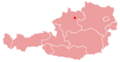 Linz in Österreich
 Luxemburg in Europa
 Bayern in Deutschland
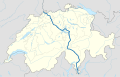 Hauptstraße 2 in CH
 Campuskarte


 Balkan (fr, 1915)
 Madeira (US, 1976)
 Pyrenäen (WP-Mashup, 2007)
 Prag (OSM, 2020)
 Machakos, Kenia (OSM 2022)
 Hydrotopographie in Luhansk


 Geologie auf Landes-...
 ...und Gemeindeebene.
 Wahlergebniskarte (Schweiz, 2011)
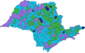 Wahlergebniskarte (Sao Paulo, 1947)
 Verbreitungsgebiete von Tieren


 Cricket-Weltmeisterschaft 1975
 Weltbevölkerungsdichte
 Europäisches BSP 2007
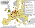 BSP europäischer Metropolen, 2018
 Waffenverbreitungsgebiete...
.png)


 Eisenbahnnetz Frankreich (1878)
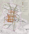 Verkehrsachsen Mexico City (2020)
 Schemakarte Dortmund
 Schemakarte Welt
 Geographische Karte Wien
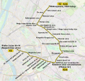 Und mit OSM-Hintergrund, Budapest
.jpg)


 Japan, 1844
 Europe Centrale, 1878
 Linz, 1911
 Welt, 1696
 "Frisland", 1562
 T. Peutingeriana, 11??

.jpg)
_(14778900605).jpg)

.jpg)


 Reich AdG (von 2006)
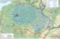 Deu-Fra Krieg 1871
 Alter Orient, 2400 v. Chr.
 Postklassisches Mayareich, 1500


 Alte Illustrationen zu Antiken Geographien
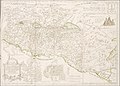 "Landnahme Israels"
 AdG - 1730er
 AdG - 1890er

.jpg)
_(14802185453).jpg)
 Indischer Ozean
 Madagaskar
 Ausschnitt von Indonesien
 Braun-Karte von Paris
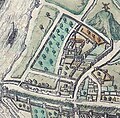 Abtei St. Viktor in Paris
.jpg)


 Weltweiter Fleischverzehr...
 Europäische Geburtenraten...
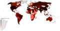 Tomatenanbau...
 Türkendichte...
 ...Reichtum?
 random comparison
 rodents and humans


 Wem nutzen...
 ...diese Karten?
 La Sibérie originale...
 ... et digitalizée.
.jpg)
,_Acervo_do_Museu_Paulista_da_USP.jpg)
.jpg)
