Category:Toponymic maps
Jump to navigation
Jump to search
Subcategories
This category has only the following subcategory.
Media in category "Toponymic maps"
The following 16 files are in this category, out of 16 total.
-
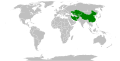
 "-stan" regions (orthographic projection).svg 553 × 553; 305 KB
-
 -kand regions.svg 2,754 × 1,398; 1.1 MB
-
 Bienhornschanze, Werk Glockenberg und Fort Rheinhell in heutiger Lage.jpg 2,825 × 4,006; 4.06 MB
-
 Countries named after people12.png 1,024 × 570; 153 KB
-
 Countries with -abad in their cities.svg 2,754 × 1,398; 1.1 MB
-
 Endonyms of the World.svg 1,368 × 936; 17.67 MB
-
 Iranian origin names in the world.svg 2,754 × 1,398; 1.11 MB
-
 Map of Countries with Names Ending in '-stan'.png 3,120 × 1,457; 653 KB
-
 Map Origin of Transylvanian Watercourse Names.jpg 2,024 × 2,343; 452 KB
-
 People's Republics.png 785 × 785; 35 KB
-
 Persian origin names in the world.svg 2,754 × 1,398; 1.12 MB
-
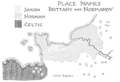 PSM V51 D318 Place names of brittany and normandy.png 1,630 × 1,109; 417 KB
-
 PSM V52 D169 Origin of place names of the british isles.png 1,960 × 3,073; 395 KB
-
 Solar System in Thai Sign Language.png 2,459 × 1,739; 293 KB
-
 Stansuffixmap.png 862 × 800; 236 KB
-
 Topónimos germânicos em Portugal.png 2,080 × 2,108; 1.36 MB
.svg)


