File talk:Venezuela (orthographic projection).svg
 | This file was nominated for deletion on 9 October 2016 but was kept. If you are thinking about re-nominating it for deletion, please read that discussion first. |
Issues[edit]
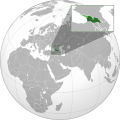
Venezuela should be fixed: Guyana must be unmarked.
Español[edit]
En vista de la permanente reversión del archivo es necesario aclarar las bases legales que sustentan el hecho de mostrar el área en disputa en el mapa localizador.
En primer lugar, existe un tratado internacional (actualmente vigente) firmado entre Venezuela, el Reino Unido de Gran Bretaña e Irlanda del Norte; y la Guayana inglesa (posteriormente Guyana). Este tratado internacional validado y certificado por las Naciones Unidas reza en su primer artículo lo siguiente:
Artículo I: Se establece una Comisión Mixta con el encargo de buscar soluciones satisfactorias para el arreglo práctico de la controversia entre Venezuela y el Reino Unido surgida como consecuencia de la contención venezolana de que el Laudo arbitral de 1899 sobre la frontera entre Venezuela y Guayana Británica es nulo e írrito. Acuerdo de Ginebra (1966)
En segundo lugar, basandose en uno de los principios fundamentales de Wikipedia, el PDVN y cuyos estatutos rezan literalmente lo siguiente:
"Editar desde un punto de vista neutral (PDVN) significa reflejar de manera justa, proporcionada y, en la medida de lo posible, sin sesgo, todos los puntos de vista significativos que hayan sido publicados por fuentes fiables [n 1]. Constituye, junto a Lo que Wikipedia no es, uno de los principios fundamentales que guían el proyecto Wikipedia. Según Jimbo Wales, fundador del proyecto, el PVN (en inglés Neutral Point of View - NPOV), es «absoluto e innegociable».'."
No mostrar el área en disputa entre Venezuela y Guyana es una clara violación de estos principios, porque se está ignorando el punto de vista legal e histórico venezolano. El mapa muestra un territorio en disputa, no una anexión territorial.
Habida cuenta de casos similares alrededor del mundo, en cuyos mapas localizadores de Wikipedia aparecen reflejadas sus respectivas zonas en disputa; y que a manera ilustrativa se reproducen algunos de ellos a continuación:
-

China
Mostrando a Taiwan y territorio disputado con India -

India
Mostrando a Cachemira en disputa con Pakistán -

Pakistán
Mostrando a Cachemira en disputa con India -

Argentina
Muestra a las Malvinas y la reclamación antártica -

Chile
Muestra la reclamación antártica -

Marruecos
Muestra disputa con Sahara Occidental -
Georgia
Muestra disputa con Abjasia y Osetia del Sur -

Israel
Muestra Palestina y disputa de Altos de Golán
.svg)
.svg)
.svg)
.svg)
.svg)
_highlighted.svg)
.svg)
.svg)
.svg)
.svg&action=edit§ion=1)
.svg&action=edit§ion=2)
Sirve todo esto para demostrar el sustento jurídico, además de cumplir los principios fundamentales de Wikipedia; que permiten plasmar la disputa territorial en el mapa VEN orthographic.svg. Toda vez que Wikipedia posee contenido enciclopédico basado en fuentes verificables; de manera que cumplidos todos estos criterios es necesario mostrar dicha disputa territorial en el mapa. En base a lo anterior, procedo a revertir el mapa a su versión correcta. También se debería tener en cuenta este argumento respecto al mapa localizador de Guyana.
Fuentes[edit]
.svg&action=edit§ion=3)
--Unukalhai (talk) 10:46, 22 October 2013 (UTC)
.svg#c-Unukalhai-2013-10-22T10:46:00.000Z-Fuentes)
English[edit]
.svg&action=edit§ion=4)
In view of the constant reversal of the file it is necessary to clarify the legal basis which support the showing of the disputed area on the map.
First, there is an international treaty (currently in force) signed by Venezuela, the United Kingdom of Great Britain and Northern Ireland, and British Guiana (later Guyana). This international treaty validated and certified by the United Nations says in his first article the following:
Article I: A Mixed Commission shall be established with the task of seeking satisfactory solutions for the practical settlement of the controversy between Venezuela and the United Kingdom which has arisen as the result of the Venezuelan contention that the Arbitral Award of 1899 a about the frontier between British Guiana and Venezuela is null and void. Treaty of Geneva (1966)
Second, based in one of Wikipedia's three core content policies, the NPOV; and wich statutes literally says the following:
"Editing from a neutral point of view (NPOV) means representing fairly, proportionately, and, as far as possible, without bias, all of the significant views that have been published by reliable sources [n 1] on a topic. All Wikipedia articles and other encyclopedic content must be written from a neutral point of view. NPOV is a fundamental principle of Wikipedia and of other Wikimedia projects. This policy is nonnegotiable and all editors and articles must follow it."
Not showing of the disputed area between Venezuela and Guyana clearly violates these policies, because it is ignoring the Venezuelan legal and historic point of view. The map shows a disputed territory, not a territorial annexion.
Having known similar cases worldwide, shown on their locator maps on Wikipedia, and for illustrative purposes some of them are reproduced below:
-
China
Showing Taiwan and Xizang dispute with India -
India
Showing Kashmir dispute with Pakistan -
Pakistan
Showing Kashmir dispute with India -
Argentina
Showing Falklands and antarctic reclamation -
Chile
Showing antarctic reclamation -
Morocco
Showing dispute with Western Sahara -
Georgia
Showing Abkhazia and South Ossetia dispute with Russia -
Israel
Showing palestinian and Golan Heights disputed land
All of this demonstrates the international legal support besides the Wikipedia policies, that allows the displaying of the disputed area on the VEN orthographic.svg map. Since Wikipedia has encyclopedic content adjusted to verifiable sources, and fulfilled all of these requirement is necessary to show this territorial dispute on the map. Based on that, I am proceeding to reverse the map to its correct version. This argument also should be considered regarding Guyana Locator map.
Sources[edit]
.svg&action=edit§ion=5)
--Unukalhai (talk) 10:46, 22 October 2013 (UTC)
.svg#c-Unukalhai-2013-10-22T10:46:00.000Z-Sources)
- I reverted it to the NPOV version without claims. This map should only show Venezuela without any claims whatsoever. This must be true for every other standard map as well. There's always the option to upload the claims map under a different name if a local project prefers this version. This should be clearly named as file with venezuelan claims upon Guyana. --Denniss (talk) 16:51, 16 November 2013 (UTC)
.svg#c-Denniss-2013-11-16T16:51:00.000Z-Unukalhai-2013-10-22T10:46:00.000Z)
mapa de venezuela[edit]
.svg&action=edit§ion=6)
wikipedia no esta repetando los articulo e mapas ,por que colombia si puede incluir su territorio maritimo en reclacion ,por que en venezuela ajuro no lo puede tener ,esto es una pelea de guerra de ediciones ,venezueal tiene en todo derecho de tener su sona en reclamacion --Colaborado12 (talk) 16:58, 17 May 2014 (UTC)
.svg#c-Colaborado12-2014-05-17T16:58:00.000Z-mapa_de_venezuela)
.svg&oldid=209805592)