File:Zeeland 3-Region Map.png
Jump to navigation
Jump to search

Size of this preview: 622 × 600 pixels. Other resolutions: 249 × 240 pixels | 498 × 480 pixels | 1,006 × 970 pixels.
Original file (1,006 × 970 pixels, file size: 29 KB, MIME type: image/png)
Captions
Captions
Add a one-line explanation of what this file represents
Summary[edit]
| Description |
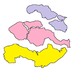
English: Map of the regions of the Dutch province of Zeeland. Current lay-out is not official - intended for use on Wikivoyage.
Yellow: Zeeuws-Vlaanderen Pink: Midden-Zeeland Blue: Noord-Zeeland. Nederlands: Kaart van de regios in de Nederlandse provincie Zeeland. Afgebeelde verdeling in regio's is niet officieel - bedoeld voor gebruik op Wikivoyage. Geel: Zeeuws-Vlaanderen Roze: Midden-Zeeland Blauw: Noord-Zeeland. |
| Date | |
| Source | Own work |
| Author | Wauteurz |
Licensing[edit]
I, the copyright holder of this work, hereby publish it under the following license:
This file is licensed under the Creative Commons Attribution-Share Alike 4.0 International license.
- You are free:
- to share – to copy, distribute and transmit the work
- to remix – to adapt the work
- Under the following conditions:
- attribution – You must give appropriate credit, provide a link to the license, and indicate if changes were made. You may do so in any reasonable manner, but not in any way that suggests the licensor endorses you or your use.
- share alike – If you remix, transform, or build upon the material, you must distribute your contributions under the same or compatible license as the original.
File history
Click on a date/time to view the file as it appeared at that time.
| Date/Time | Thumbnail | Dimensions | User | Comment | |
|---|---|---|---|---|---|
| current | 10:58, 18 September 2016 | | 1,006 × 970 (29 KB) | Wauteurz (talk | contribs) | User created page with UploadWizard |
You cannot overwrite this file.
File usage on Commons
The following page uses this file: